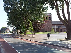
| Breedeweg | |
|---|---|
| Village | |
 St. Antonius church St. Antonius church | |
  | |
| Coordinates: 51°45′28″N 5°56′25″E / 51.7578°N 5.9402°E / 51.7578; 5.9402 | |
| Country | Netherlands |
| Province | Gelderland |
| Municipality | Berg en Dal |
| Area | |
| • Total | 5.45 km (2.10 sq mi) |
| Elevation | 37 m (121 ft) |
| Population | |
| • Total | 2,570 |
| • Density | 470/km (1,200/sq mi) |
| Time zone | UTC+1 (CET) |
| • Summer (DST) | UTC+2 (CEST) |
| Postal code | 6562 |
| Dialing code | 024 |
Breedeweg is a village in the Dutch province of Gelderland. It is located in the municipality of Berg en Dal, about 1 km south of Groesbeek.
It was first mentioned in 1899 as Breedeweg, and means "wide road". The St. Antonius Church was built in 1934, and destroyed in 1944 during Operation Market Garden. In 1949, the church was rebuilt, and a monument has been erected for the dead allied soldiers and the two civilians who were killed by a grenade while cleaning up the debris.
Breedeweg and Groesbeek have been expanding, and are now close to one-another. In the late 2010s, the municipality changed the place name sign to "Groesbeek Breedeweg". Nevertheless, it is still a separate village and not annexed.
Gallery
References
- ^ "Kerncijfers wijken en buurten 2021". Central Bureau of Statistics. Retrieved 20 March 2022.
- "Postcodetool for 6562AA". Actueel Hoogtebestand Nederland (in Dutch). Het Waterschapshuis. Retrieved 20 March 2022.
- ANWB Topografische Atlas Nederland, Topografische Dienst and ANWB, 2005.
- "Breedeweg - (geografische naam)". Etymologiebank (in Dutch). Retrieved 20 March 2022.
- ^ "Breedeweg". Plaatsengids (in Dutch). Retrieved 20 March 2022.
| Populated places in the municipality of Berg en Dal | |
|---|---|
| Towns | |
| Villages | |
| Hamlets | |
| List of cities, towns and villages in Gelderland | |
This Gelderland location article is a stub. You can help Misplaced Pages by expanding it. |


