| Brno-Bohunice | |
|---|---|
| City District of Brno | |
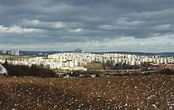
 Apartment flats in Brno-Bohunice viewed from the south Apartment flats in Brno-Bohunice viewed from the south | |
 Flag Flag Coat of arms Coat of arms | |
 Location of Bohunice in Brno
49°10′10″N 16°34′45″E / 49.16944°N 16.57917°E / 49.16944; 16.57917 Location of Bohunice in Brno
49°10′10″N 16°34′45″E / 49.16944°N 16.57917°E / 49.16944; 16.57917 | |
| Country | Czech Republic |
| Region | South Moravia |
| City | Brno |
| Government | |
| • Mayor | Antonín Crha (KDU-ČSL) |
| Area | |
| • Total | 3.02 km (1.17 sq mi) |
| Population | |
| • Total | 13,671 |
| • Density | 4,500/km (12,000/sq mi) |
| Time zone | UTC+1 (CET) |
| • Summer (DST) | UTC+2 (CEST) |
| Postal code | 625 00 |
| Website | https://www.brno-bohunice.cz/ |
Brno-Bohunice is a city district of Brno, the second largest city in the Czech Republic. It is made up of the cadastral territory of Bohunice.
It is located in the southwest part of the city. It is first mentioned in 1237. It began growing rapidly at the beginning of the 18th century. In 1919, Bohunice officially became part of Brno, which meant further growth. Street names first appeared in 1925. In 1921, Bohunice had 202 houses and 1463 inhabitants. Today's statistics show that Bohunice had about 614 houses with 14,212 inhabitants as of 2021.
Until 1975, Bohunice was just a small district at one end of the city of Brno, connected with the city center by a bus route. In the 1970s many housing developments were built, which increased the district's population to 13,000 by the end of the decade.
Today, there are several tram lines, bus lines and trolleybus lines, which serve the transport to and from the city center. On its eastern side it neighbors the major Brno graveyard, the Central Cemetery, and the western part neighbors the district of Starý Lískovec.
Today Bohunice is probably best known for its hospital: it is the largest hospital in Moravia and one of the biggest hospitals in the Czech Republic. Recently, the hospital area was expanded greatly and the faculty of science and engineering of Masaryk University was relocated here and is now known as the Univerzitní kampus. The entire complex, now named Campus, was then expanded even further by building a shopping mall and a TESCO nearby.
Territorial divisions
The cadastral territory of Bohunice is further divided into 6 basic settlement units.
| Basic settlement unit | Population | ||
|---|---|---|---|
| 2011 | 2021 | Change | |
| Bohunice-střed | 5,023 | 4,604 | -8.3% |
| Ukrajinská | 4,800 | 4,556 | -5.1% |
| Okrouhlá | 4,108 | 3,696 | -10.0% |
| Pomologický ústav | 215 | 213 | -0.9% |
| Kejbaly | 537 | 1,106 | +106.0% |
| Červený kopec-jih | - | 37 | - |
Demographics
|
|
| ||||||||||||||||||||||||||||||||||||||||||||||||||||||
| Source: Censuses | ||||||||||||||||||||||||||||||||||||||||||||||||||||||||
References
- "Participative budget in the city districts of Brno" (in Czech). Czech Statistical Office. 2023-01-01.
- "V. Basic data for municipalities, parts of municipalities and basic settlement units: Brno-City District" (PDF) (in Czech). Czech Statistical Office.
- "Results of the 2021 Census - Open data". Public Database (in Czech). Czech Statistical Office. 2021-03-27.
- "Historický lexikon obcí České republiky 1869–2011 – Okres Brno-město" (in Czech). Czech Statistical Office. 2015-12-21. pp. 7–8.
- "Population Census 2021: Population by sex". Public Database. Czech Statistical Office. 2021-03-27.
External links
This South Moravian Region location article is a stub. You can help Misplaced Pages by expanding it. |