| Bronnegerveen Brönnegerveen | |
|---|---|
| Hamlet | |
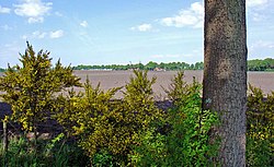
 View on the Hondsrug in Bronnegerveen View on the Hondsrug in Bronnegerveen | |
 The village (dark red) and the statistical district (light green) of Bronnegerveen in the municipality of Borger-Odoorn. The village (dark red) and the statistical district (light green) of Bronnegerveen in the municipality of Borger-Odoorn. | |
| Coordinates: 52°57′N 6°50′E / 52.950°N 6.833°E / 52.950; 6.833 | |
| Country | Netherlands |
| Province | Drenthe |
| Municipality | Borger-Odoorn |
| Area | |
| • Total | 7.21 km (2.78 sq mi) |
| • Land | 7.16 km (2.76 sq mi) |
| • Water | 0.05 km (0.02 sq mi) |
| Elevation | 9 m (30 ft) |
| Population | |
| • Total | 85 |
| • Density | 12/km (31/sq mi) |
| Time zone | UTC+1 (CET) |
| • Summer (DST) | UTC+2 (CEST) |
| Postal code | 9526 |
| Dialing code | 0599 |
Bronnegerveen is a hamlet in the Dutch province of Drenthe. It is a part of the municipality of Borger-Odoorn, and lies about 19 km east of Assen.
The hamlet was first mentioned in 1936 as Bronnegerveen, and means "peat excavation village near Bronneger". The settlement started around 1750. A century later, it became a peat excavation village.
References
- ^ "Kerncijfers wijken en buurten 2021". Central Bureau of Statistics. Retrieved 11 April 2022.
- "Postcodetool for 9526TA". Actueel Hoogtebestand Nederland (in Dutch). Het Waterschapshuis. Retrieved 11 April 2022.
- "Bronnegerveen - (geografische naam)". Etymologiebank (in Dutch). Retrieved 11 April 2022.
- "Bronnegerveen". Plaatsengids (in Dutch). Retrieved 11 April 2022.
| Populated places in the municipality of Borger-Odoorn | |
|---|---|
| Villages | |
| Hamlets | |
| List of cities, towns and villages in Drenthe | |
This Drenthe location article is a stub. You can help Misplaced Pages by expanding it. |