| This article does not cite any sources. Please help improve this article by adding citations to reliable sources. Unsourced material may be challenged and removed. Find sources: "Brussels tram route 55" – news · newspapers · books · scholar · JSTOR (August 2023) (Learn how and when to remove this message) |
| STIB/MIVB Route 55 | ||||||
|---|---|---|---|---|---|---|
| Da Vinci – Rogier | ||||||
 T3035 at Verboekhoven T3035 at Verboekhoven | ||||||
| Overview | ||||||
| System | Brussels tramway network | |||||
| Operator | STIB/MIVB | |||||
| Depot | Haren, Schaerbeek | |||||
| Vehicle | T3000 | |||||
| Status | Operational | |||||
| Began service | 6 July 1968 (1968-07-06) | |||||
| Route | ||||||
| Locale | Brussels, Belgium | |||||
| Communities served | Evere Schaerbeek City of Brussels | |||||
| Start | Da Vinci | |||||
| End | Rogier | |||||
| Length | 5.9 km (3.7 mi) | |||||
| Service | ||||||
| Journey time | 20 minutes | |||||
| ||||||
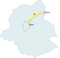
The Brussels tram route 55 is a tram route in Brussels, Belgium, operated by STIB/MIVB, which connects Bordet railway station in the municipality of Evere, north-east of Brussels, to Rogier metro station in the City of Brussels. The route also crosses the municipalities of Saint-Josse and Schaerbeek. The route was cut in the 2000s with STIB/MIVB willing to reduce the number of tram routes riding in the North–South Axis. Prior to this, the route went on up to the southern municipality of Uccle at the Silence stop. A part of this section is now served by Brussels tram route 51.
See also
External links
| Brussels Metro |  | |
|---|---|---|
