Hospital in England
| Buntingford almshouses | |
|---|---|
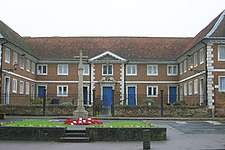
 Buntingford Almshouses, with war memorial in the foreground Buntingford Almshouses, with war memorial in the foreground | |
| Geography | |
| Location | Buntingford, Hertfordshire, England, United Kingdom |
| Organisation | |
| Funding | Government hospital |
| Services | |
| Emergency department | No Accident & Emergency |
| History | |
| Opened | 1684 |
| Links | |
| Lists | Hospitals in England |
Buntingford Almshouses is a Grade II* listed building on the high street of the Hertfordshire town of Buntingford. The building was erected in 1684 by the mathematician and astronomer Bishop Seth Ward who was born in the town. The architect was probably the scientist and architect, Robert Hooke.
The building, located next to St Peter's Church, is built of brick around three sides of a courtyard. The heritage listing describes the building as " classical almshouses of 1684 of outstanding interest."
Having previously been used as the local hospital, the building is now run by a charity to provide accommodation for elderly people in the town.
References
- ^ Historic England. "Details from listed building database (1101350)". National Heritage List for England. Retrieved 16 November 2013.
- Batten, M. I. (1936–1937). "The architecture of Dr Robert Hooke F.R.S.". The Volume of the Walpole Society. 25: 110.
- "Buntingford Almshouses, registered charity no. 240885". Charity Commission for England and Wales.
51°56′45″N 0°01′00″W / 51.9457°N 0.0168°W / 51.9457; -0.0168
This article about a Hertfordshire building or structure is a stub. You can help Misplaced Pages by expanding it. |