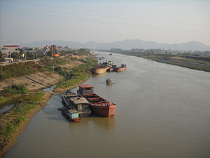
| Cầu River | |
|---|---|
 Cầu River at Việt Yên, Bắc Giang Cầu River at Việt Yên, Bắc Giang | |
| Physical characteristics | |
| Source | |
| • location | Chợ Đồn District |
| Mouth | |
| • location | Thái Bình River |
| • coordinates | 21°07′26″N 106°17′52″E / 21.12389°N 106.29778°E / 21.12389; 106.29778 |
| Length | 288 km (179 mi) |
| Basin size | 6,030 km (2,330 sq mi) |
| Basin features | |
| Tributaries | |
| • left | Cà Lồ River, Công River |
Cầu River (Vietnamese: Sông Cầu) is a river of northern Vietnam. It flows through the provinces/cities of Bắc Kạn, Thái Nguyên, Bắc Giang, Hanoi, Bắc Ninh. It begins at the Phia Bioóc Peak in Chợ Đồn District, west of mountainous province of Bắc Kạn.
The river has a length of 288 km and basin area of 6,030 km².
References
- Phung, Hieu (December 2020). "Naming the Red River — becoming a Vietnamese river". Journal of Southeast Asian Studies. 51 (4): 518–537. doi:10.1017/S0022463421000011. ISSN 0022-4634.
- Giuliani, Silvia; Romanelli, Margherita; Piazza, Rossano; Vecchiato, Marco; Pizzini, Sarah; Tranchida, Giorgio; D’Agostino, Fabio; Romano, Stefania; Bellucci, Luca Giorgio (2019-11-01). "When research meets NGOs: The GVC-UCODEP project in the Bắc Giang Province and Cầu River (Northern Vietnam) and its feedback on national monitoring programs". Environmental Science & Policy. 101: 279–290. doi:10.1016/j.envsci.2019.09.004. ISSN 1462-9011.
External links
This article related to a river in Vietnam is a stub. You can help Misplaced Pages by expanding it. |