| Cajatambo Qaqatampu | |
|---|---|
| District | |
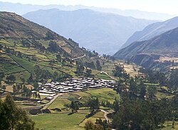
 The village of Astobamba, Cajatambo District The village of Astobamba, Cajatambo District | |
| Country | |
| Region | Lima |
| Province | Cajatambo |
| Capital | Cajatambo |
| Government | |
| • Mayor | José Del Carmen Flores Fuentes Rivera (2019-2022) |
| Area | |
| • Total | 567.96 km (219.29 sq mi) |
| Elevation | 3,376 m (11,076 ft) |
| Population | |
| • Total | 2,082 |
| • Density | 3.7/km (9.5/sq mi) |
| Time zone | UTC-5 (PET) |
| UBIGEO | 150301 |
Cajatambo, Kashatampu, or Qaqatampu (Quechua) is one of five districts of the province Cajatambo in Peru.
Geography
The Waywash mountain range traverses the district. Some of the highest peaks of the district are listed below:
- Awkin
- Challwaqucha
- Chhanka
- Ichik Qayqu
- Millpu
- Misapata
- Mishi Waqanan
- Mit'u Punta
- Muntiqucha
- Parya Ukru
- Pishtaq
- Puka Qaqa
- Puka Qaqa (Mun.)
- Puskan T'urpu
- Phuyuq
- Qullqan
- Suyruqucha
- Shawanaqucha
- Waqshash
- Waylla Hirka
- Waylla Hirka (Caj.)
- Yana Kushman
- Yana Hirka
- Yana Paryan
- Yana Uqsha
- Yuraq Hirka
- Yuraq Qaqa
See also
References
- (in Spanish) Instituto Nacional de Estadística e Informática. Banco de Información Distrital Archived April 23, 2008, at the Wayback Machine. Retrieved April 11, 2008.
- escale.minedu.gob.pe UGEL map of the Cajatambo Province (Lima Region)
This Lima Region geography article is a stub. You can help Misplaced Pages by expanding it. |
10°28′17″S 76°59′36″W / 10.4713°S 76.9933°W / -10.4713; -76.9933
Categories: