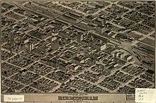
Camille N. Drie, also known as Camille N. Dry, was a draughtsman active from ca. 1871 to 1904 in the United States. Drie created pictorial maps of various cities including a 110-sheet view of St. Louis, Missouri (1875). The Library of Congress has a collection of his work.


Drie also produced pictorial maps of Galveston, Texas; Anniston, Alabama, and Vicksburg, Mississippi.
He worked with Richard J. Compton on the St. Louis mapping project.
See also
References
- dry, camille n. "Search results from Panoramic Maps, Dry, Camille N., Pictorial St. Louis, the great metropolis of the Mississippi valley; a topographical survey drawn in perspective A.D. 1875, (g4164sm.gpm00001/)". Library of Congress.
- "Bird's eye view looking northwest, city of Anniston, Calhoun County, Alabama".
- Reps, John William (May 9, 1984). Views and Viewmakers of Urban America: Lithographs of Towns and Cities in the United States and Canada, Notes on the Artists and Publishers, and a Union Catalog of Their Work, 1825-1925. University of Missouri Press. p. 172. ISBN 9780826204165 – via Internet Archive.
Camille N. Drie.
- "Pictorial Louis Great Metropolis Mississippi by Dry Camille - AbeBooks".