Place in South Australia
| Cape Jaffa Cape Jaffa, South Australia | |
|---|---|
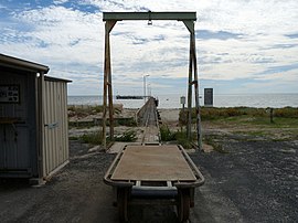
 The Cape Jaffa jetty and a trolley that runs on the railway line, used for moving seafood from the boats to the coldstores behind the jetty The Cape Jaffa jetty and a trolley that runs on the railway line, used for moving seafood from the boats to the coldstores behind the jetty | |
 | |
| Coordinates | 36°57′21″S 139°40′13″E / 36.955955°S 139.670413°E / -36.955955; 139.670413 |
| Population | 66 (SAL 2021) |
| Location | 20 km (12 mi) south west of Kingston SE |
Cape Jaffa is a headland in the Australian state of South Australia located at the south end of Lacepede Bay on the state's south east coast about 20 kilometres (12 miles) south west of the town centre of Kingston SE. The cape is described as being "a low sandy point" with "its sea face is about One nautical mile (1.9 km) long" and having a "wooded range rises near the S part of the cape and reaches a height of 77 metres (253 feet) at Mount Benson, about 8.5 nautical miles (15.7 kilometres) S E". A settlement known as King's Camp in some sources and as Cape Jaffa in other sources is located about 0.5 nautical miles (0.93 kilometres) to the north west of the cape. This settlement includes a jetty fitted with a navigation aid and a marina. The southern coastline of the cape forms part of the Bernouilli Conservation Reserve.
See also
References
- "Search result for 'Cape Jaffa, CAPE' using datasets for 'Suburbs and Localities' and 'Gazetteer'". Location SA Map Viewer. Government of South Australia. Retrieved 12 February 2019.
- Australian Bureau of Statistics (28 June 2022). "Cape Jaffa (suburb and locality)". Australian Census 2021 QuickStats. Retrieved 28 June 2022.

- Sailing Directions (Enroute), Pub. 175: North, West, and South Coasts of Australia (PDF). Sailing Directions. United States National Geospatial-Intelligence Agency. 2017. p. 229.
- South Australia. Department of Marine and Harbors (1985), The Waters of South Australia a series of charts, sailing notes and coastal photographs, Dept. of Marine and Harbors, South Australia, pp. Chart 6, ISBN 978-0-7243-7603-2
- Boating Industry Association of South Australia (BIA); South Australia. Department for Environment and Heritage (2005), South Australia's waters an atlas & guide, Boating Industry Association of South Australia, p. 180, ISBN 978-1-86254-680-6
- "Cape Jaffa Code SSC40092 (SSC)". Australian Bureau of Statistics. Retrieved 15 November 2014.
- "Cape Jaffa Anchorage". The Australian Marinas Guide. Archived from the original on 26 January 2014. Retrieved 30 July 2014.
External links
This South Australia geography article is a stub. You can help Misplaced Pages by expanding it. |