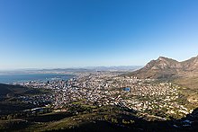
The City Bowl is a part of Cape Town in South Africa. It is a natural amphitheatre-shaped area bordered by Table Bay and defined by the mountains of Signal Hill, Lion's Head, Table Mountain and Devil's Peak.
The area includes the central business district of Cape Town (CBD), the harbour, the Company's Garden, and the residential suburbs of De Waterkant, Devil's Peak Estate, District Six, Zonnebloem, Gardens, Higgovale, Oranjezicht, Schotsche Kloof, Tamboerskloof, University Estate, Vredehoek, Walmer Estate and Woodstock.
Central Business District
Cape Town CBD in the City Bowl is a major business district in Cape Town’s metropolitan area and a financial centre of the Western Cape and South Africa. The South African parliament is located in Plein Street, and is the seat of government for six months in the year. The Western Cape provincial government and City of Cape Town metropolitan municipality also have their head offices in the Cape Town CBD.
This district’s inner-city shopping space is currently undergoing a change. The Old Mutual Centre, on the corner of Strand Street and Adderley Street, is being transformed into The Mutual. Anchored by Checkers, Checkers Liquor and Mr Price, the new centre is scheduled to open in April 2024. It will be situated by one of the busiest public transport interchanges in the Cape Metropole with Cape Town Station Deck being a hub for approximately 200,000 daily commuters.
Foreshore Freeway bridge
Main article: Foreshore Freeway BridgeThe Foreshore Freeway Bridge has stood in its unfinished state since construction officially ended in 1977. It was intended to be the Eastern Boulevard Highway in the city bowl, but is unfinished due to budget constraints.
Gallery
-
 Map of the City Bowl
-
 An aerial panoramic of Cape Town's City Bowl taken from above Signal Hill looking north.
-
 City Bowl and Table Mountain at dawn
-
 An aerial view of the city bowl from the harbour with Table Mountain in the background.
-
 City Bowl from Signal Hill at night
-
 City Bowl from the M3 freeway.
References
- "Old Mutual Centre".
- "The Mutual - Retail Opportunities Backed by Exceptional Foot Traffic". www.rennieproperty.co.za. Retrieved 2023-11-09.
- Africa, Tamaryn (24 June 2019). "City of Cape Town decorates station deck with colourful murals". IOL.
External links
33°56′S 18°25′E / 33.933°S 18.417°E / -33.933; 18.417
| Communities of City of Cape Town Metropolitan Municipality, Western Cape | |||||
|---|---|---|---|---|---|
| Seat: Cape Town | |||||
| Atlantic Seaboard |  | ||||
| Blaauwberg | |||||
| Cape Flats |
| ||||
| City Centre | |||||
| Helderberg | |||||
| Islands | |||||
| Northern Suburbs | |||||
| Southern Suburbs | |||||
| South Peninsula | |||||