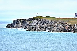
| Cape Vankarem мыс Ванкарем | |
|---|---|
| Cape | |
 View of Cape Vankarem View of Cape Vankarem | |
 | |
| Coordinates: 67°50′55″N 175°48′24″W / 67.84861°N 175.80667°W / 67.84861; -175.80667 | |
| Location | Chukotka, |
| Offshore water bodies | Chukchi Sea |
Cape Vankarem is a cape in the Chukchi Sea on the northern coast of Chukotka between Cape Schmidt to the west and Kolyuchinskaya Bay to the east. It projects from a sandspit across the mouth of a lagoon into which flows the Vankarem River. At the mouth of the lagoon is the village of Vankarem, a Chukchi settlement.
The area around cape Vankarem is bounded by narrow beach ridges and swales with numerous inlets and coastal lagoons.
History
East of Cape Vankarem, Adolf Erik Nordenskiöld observed remains of ancient dwellings, as well as numerous bones of reindeers and bears. Walruses, and whales, including bowhead and gray whales, are abundant in the waters off Cape Vankarem.
 |
 |
Climate
| Climate data for Cape Vankarem (extremes 1934-present) | |||||||||||||
|---|---|---|---|---|---|---|---|---|---|---|---|---|---|
| Month | Jan | Feb | Mar | Apr | May | Jun | Jul | Aug | Sep | Oct | Nov | Dec | Year |
| Record high °C (°F) | 1.7 (35.1) |
0.8 (33.4) |
3.1 (37.6) |
3.7 (38.7) |
13.7 (56.7) |
25.2 (77.4) |
27.1 (80.8) |
27.4 (81.3) |
19.4 (66.9) |
11.5 (52.7) |
10.5 (50.9) |
3.3 (37.9) |
27.4 (81.3) |
| Mean daily maximum °C (°F) | −21.2 (−6.2) |
−21.0 (−5.8) |
−18.5 (−1.3) |
−12.1 (10.2) |
−1.5 (29.3) |
6.5 (43.7) |
9.6 (49.3) |
7.3 (45.1) |
5.0 (41.0) |
−0.9 (30.4) |
−7.6 (18.3) |
−16.6 (2.1) |
−5.9 (21.3) |
| Daily mean °C (°F) | −24.1 (−11.4) |
−24.3 (−11.7) |
−22.2 (−8.0) |
−15.8 (3.6) |
−4.2 (24.4) |
2.9 (37.2) |
5.4 (41.7) |
4.2 (39.6) |
3.0 (37.4) |
−2.7 (27.1) |
−10.4 (13.3) |
−19.2 (−2.6) |
−9.0 (15.9) |
| Mean daily minimum °C (°F) | −26.9 (−16.4) |
−27.4 (−17.3) |
−25.6 (−14.1) |
−19.3 (−2.7) |
−6.8 (19.8) |
0.3 (32.5) |
2.6 (36.7) |
2.0 (35.6) |
1.5 (34.7) |
−4.6 (23.7) |
−13.3 (8.1) |
−21.9 (−7.4) |
−11.6 (11.1) |
| Record low °C (°F) | −44.9 (−48.8) |
−46.5 (−51.7) |
−44.6 (−48.3) |
−40.1 (−40.2) |
−28.0 (−18.4) |
−11.6 (11.1) |
−3.9 (25.0) |
−5.0 (23.0) |
−14.4 (6.1) |
−29.0 (−20.2) |
−36.3 (−33.3) |
−41.4 (−42.5) |
−46.5 (−51.7) |
| Average precipitation mm (inches) | 10.9 (0.43) |
10.3 (0.41) |
6.9 (0.27) |
8.6 (0.34) |
7.9 (0.31) |
6.2 (0.24) |
13.6 (0.54) |
20.5 (0.81) |
18.0 (0.71) |
31.5 (1.24) |
22.7 (0.89) |
14.6 (0.57) |
171.7 (6.76) |
| Source: pogoda.ru.net | |||||||||||||
See also
References
- Sighting of gray whales off Cape Vankarem
- "Климат Мыса Ванкарем" (in Russian). Retrieved December 28, 2022.
- Armstrong, T., The Russians in the Arctic, London, 1958.
External links
 Media related to Cape Vankarem at Wikimedia Commons
This Chukotka Autonomous Okrug location article is a stub. You can help Misplaced Pages by expanding it. |