| Carauari | |
|---|---|
| Municipality | |
 Flag Flag Seal Seal | |
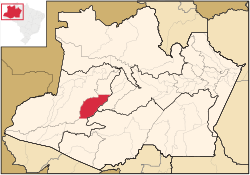
 Location of the municipality inside Amazonas Location of the municipality inside Amazonas | |
 | |
| Coordinates: 4°52′58″S 66°53′45″W / 4.88278°S 66.89583°W / -4.88278; -66.89583 | |
| Country | |
| Region | North |
| State | |
| Population | |
| • Total | 28,508 |
| Time zone | UTC−4 (AMT) |
Carauari is a municipality located in the Brazilian state of Amazonas. Its population was 28,508 (2020) and its area is 25,767 km².
The city is served by Carauari Airport.
Geography
The town is in the Juruá-Purus moist forests ecoregion. The municipality contains about 5% of the Tefé National Forest, created in 1989. The municipality contains 251,577 hectares (621,660 acres) Médio Juruá Extractive Reserve, created in 1997, on the left bank of the meandering Juruá River. It also contains the 632,949 hectares (1,564,050 acres) Uacari Sustainable Development Reserve, created in 2005.
Climate
| Climate data for Carauari | |||||||||||||
|---|---|---|---|---|---|---|---|---|---|---|---|---|---|
| Month | Jan | Feb | Mar | Apr | May | Jun | Jul | Aug | Sep | Oct | Nov | Dec | Year |
| Mean daily maximum °C (°F) | 30.0 (86.0) |
30.4 (86.7) |
30.5 (86.9) |
30.2 (86.4) |
30.9 (87.6) |
30.0 (86.0) |
30.0 (86.0) |
31.5 (88.7) |
31.9 (89.4) |
31.5 (88.7) |
31.0 (87.8) |
30.6 (87.1) |
30.7 (87.3) |
| Daily mean °C (°F) | 25.9 (78.6) |
26.4 (79.5) |
26.4 (79.5) |
26.2 (79.2) |
26.4 (79.5) |
25.8 (78.4) |
25.4 (77.7) |
26.2 (79.2) |
26.7 (80.1) |
26.6 (79.9) |
26.4 (79.5) |
26.3 (79.3) |
26.2 (79.2) |
| Mean daily minimum °C (°F) | 21.9 (71.4) |
22.4 (72.3) |
22.3 (72.1) |
22.3 (72.1) |
21.9 (71.4) |
21.7 (71.1) |
20.9 (69.6) |
21.0 (69.8) |
21.5 (70.7) |
21.8 (71.2) |
21.9 (71.4) |
22.0 (71.6) |
21.8 (71.2) |
| Average precipitation mm (inches) | 301 (11.9) |
242 (9.5) |
320 (12.6) |
307 (12.1) |
231 (9.1) |
126 (5.0) |
89 (3.5) |
105 (4.1) |
153 (6.0) |
195 (7.7) |
235 (9.3) |
283 (11.1) |
2,587 (101.9) |
| Source: http://en.climate-data.org/location/44143/ | |||||||||||||
References
- IBGE 2020
- IBGE - "Archived copy". Archived from the original on 2008-06-11. Retrieved 2008-06-11.
{{cite web}}: CS1 maint: archived copy as title (link) - Sears, Robin, South America: Amazon Basin, northwestern Brazil (NT0133), WWF: World Wildlife Fund, retrieved 2017-03-28
- FLONA de Tefé (in Portuguese), ISA: Instituto Socioambiental, retrieved 2016-10-19
- RESEX do Médio Juruá (in Portuguese), ISA: Instituto Socioambiental, retrieved 2016-06-16
- RDS de Uacari (in Portuguese), ISA: Instituto Socioambiental, retrieved 2016-09-06
| Capital: Manaus | ||||||||||||||
| Mesoregion Centro Amazonense |
|  | ||||||||||||
| Mesoregion Norte Amazonense |
| |||||||||||||
| Mesoregion Sudoeste Amazonense |
| |||||||||||||
| Mesoregion Sul Amazonense |
| |||||||||||||
This article about a location in the Brazilian state of Amazonas is a stub. You can help Misplaced Pages by expanding it. |