| Castelseprio | |
|---|---|
| Comune | |
| Comune di Castelseprio | |
 | |
 Coat of arms Coat of arms | |
| Location of Castelseprio | |
  | |
| Coordinates: 45°43′N 8°52′E / 45.717°N 8.867°E / 45.717; 8.867 | |
| Country | Italy |
| Region | Lombardy |
| Province | Varese (VA) |
| Area | |
| • Total | 3.9 km (1.5 sq mi) |
| Population | |
| • Total | 1,276 |
| • Density | 330/km (850/sq mi) |
| Demonym | Sepriesi |
| Time zone | UTC+1 (CET) |
| • Summer (DST) | UTC+2 (CEST) |
| Postal code | 21050 |
| Dialing code | 0331 |
| Website | Official website |
Castelseprio is a comune (municipality) in the Province of Varese in the Italian region Lombardy, located about 35 kilometres (22 mi) northwest of Milan and about 11 kilometres (7 mi) south of Varese, bordering the municipalities of Cairate, Carnago, Gornate-Olona and Lonate Ceppino.
The main centre, formerly known as Vico Seprio (a name still in informal local use) is near the historically significant ruins of the ancient and medieval city of Castelseprio, which are today in an archaeological zone open to the public at the normal hours. The site is most famous for the Byzantinesque frescos in the small Church of Santa Maria foris portas, a UNESCO World Heritage Site since 2011.
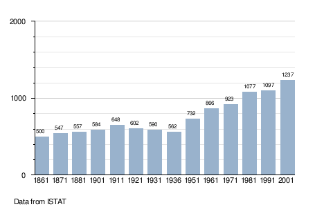
The modern village of Castelseprio has a population of 1,276 and area of 3.9 square kilometres (1.5 sq mi).
Demographic evolution

References
- "Superficie di Comuni Province e Regioni italiane al 9 ottobre 2011". Italian National Institute of Statistics. Retrieved 16 March 2019.
- "Popolazione Residente al 1° Gennaio 2018". Italian National Institute of Statistics. Retrieved 16 March 2019.
- As of 31 December 2004
- All demographics and other statistics: Italian statistical institute Istat.
This article on a location in the Province of Varese is a stub. You can help Misplaced Pages by expanding it. |