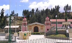
| Catac | |
|---|---|
| District | |
 Catac Catac | |
| Country | |
| Region | Ancash |
| Province | Recuay |
| Founded | January 8, 1965 |
| Capital | Catac |
| Area | |
| • Total | 1,018.27 km (393.16 sq mi) |
| Elevation | 3,566 m (11,699 ft) |
| Population | |
| • Total | 4,616 |
| • Density | 4.5/km (12/sq mi) |
| Time zone | UTC-5 (PET) |
| UBIGEO | 021702 |
Catac District is one of ten districts of the Recuay Province in Peru. Its seat is Catac.
Geography
The southern part of the Cordillera Blanca traverses the district. Some of the highest peaks of the district are listed below:
- Challwa
- Chuqi Wank'a
- Ichik Qiwlla
- Kunkush
- Kunkush Punta
- Kuntur Sinqa
- Kuntur Wayin
- Minapata
- Mururahu
- Pukarahu
- Puma Wayin
- Puywan
- Qarwaq
- Qishqi
- Qiwlla Hirka
- Qiwllarahu
- Sach'a Hirka
- Santun
- Shawanka Punta
- Tantash
- Tuku
- Wamas Chakra
- Warapaska
- Wathiyaqucha
- Wishka Hirka
- Yana Kunkush
See also
References
- (in Spanish) Instituto Nacional de Estadística e Informática. Banco de Información Distrital Archived April 23, 2008, at the Wayback Machine. Retrieved April 11, 2008.
- escale.minedu.gob.pe - UGEL map of the Recuay Province (Ancash Region)
9°48′00″S 77°26′13″W / 9.80000°S 77.43694°W / -9.80000; -77.43694
This Ancash Region geography article is a stub. You can help Misplaced Pages by expanding it. |