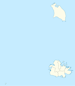
Village in Antigua, Antigua and Barbuda
Cedar Grove is a settlement in the far north of the island of Antigua . It is located to the east of the island's northernmost headlands, Boon Point . It is 6 kilometres (3.7 mi) northeast of the capital, St. John's .
History
Around the 1850s, the name of Cedar Grove was Willocks Village, although some American maps used this name until the 1940s.
Demographics
Cedar Grove is classified as "lower medium income", however, it is still one of the best parts of the nation to live in, having a Living Conditions Index of 14.26.
There are three enumeration districts in Cedar Grove.
30300 Cedar Grove-East
30400 Cedar Grove-St. James
30500 Cedar Grove-South
Ethnic data
Q48 Ethnic
Counts
%
African descendent
873
93.50%
Caucasian/White
4
0.47%
East Indian/India
3
0.35%
Mixed (Other)
30
3.19%
Hispanic
20
2.13%
Other
1
0.12%
Don't know/Not stated
2
0.24%
Total
934
100.00%
Religion
Q49 Religion
Counts
%
Adventist
119
12.83%
Anglican
358
38.48%
Baptist
46
4.99%
Church of God
12
1.31%
Evangelical
11
1.19%
Jehovah Witness
6
0.59%
Methodist
6
0.59%
Moravian
149
16.03%
Nazarene
2
0.24%
None/no religion
43
4.63%
Pentecostal
27
2.85%
Rastafarian
9
0.95%
Roman Catholic
27
2.85%
Weslyan Holiness
81
8.67%
Other
20
2.14%
Don't know/Not stated
15
1.66%
Total
930
100.00%
Country of birth
Q58. Country of birth
Counts
%
Antigua and Barbuda
744
79.67%
Other Caribbean countries
7
0.71%
Canada
3
0.35%
Dominica
21
2.25%
Dominican Republic
17
1.77%
Guyana
23
2.48%
Jamaica
44
4.73%
Monsterrat
2
0.24%
St. Kitts and Nevis
1
0.12%
St. Lucia
7
0.71%
St. Vincent and the Grenadines
2
0.24%
Trinidad and Tobago
3
0.35%
United Kingdom
7
0.71%
USA
35
3.78%
USVI United States Virgin Islands
7
0.71%
Not Stated
11
1.18%
Total
934
100.00%
Country of citizenship
Q71 Country of Citizenship 1
Counts
%
Antigua and Barbuda
805
86.17%
Other Caribbean countries
7
0.71%
Canada
1
0.12%
Dominica
9
0.95%
Dominican Republic
14
1.54%
Guyana
20
2.13%
Jamaica
35
3.78%
Monsterrat
2
0.24%
St. Lucia
4
0.47%
St. Vincent and the Grenadines
1
0.12%
United Kingdom
4
0.47%
USA
23
2.48%
Not Stated
8
0.83%
Total
934
100.00%
Country of second citizenship
Q71 Country of Citizenship 2
Counts
%
Other Caribbean countries
6
6.76%
Canada
2
2.70%
Dominica
12
14.86%
Dominican Republic
4
5.41%
Guyana
8
9.46%
Jamaica
9
10.81%
St. Lucia
6
6.76%
St. Vincent and the Grenadines
1
1.35%
Trinidad and Tobago
3
4.05%
United Kingdom
4
5.41%
USA
24
29.73%
Other countries
1
1.35%
Not Stated
1
1.35%
Total
82
100.00%
NotApp :
852
References
"ANTIGUA & BARBUDA'S CULTURAL HERITAGE" . antiguahistory.net . Retrieved 2022-05-15.^ "Antigua and Barbuda::Statistics Division/Redatam Webserver | Statistical Process and Dissemination Tool" . redatam.org . Retrieved 2021-12-15.
Parish of Saint John Populated places
Geographical features
History and culture
Landmarks and tourism
Categories :
Text is available under the Creative Commons Attribution-ShareAlike License. Additional terms may apply.
**DISCLAIMER** We are not affiliated with Wikipedia, and Cloudflare.
The information presented on this site is for general informational purposes only and does not constitute medical advice.
You should always have a personal consultation with a healthcare professional before making changes to your diet, medication, or exercise routine.
AI helps with the correspondence in our chat.
We participate in an affiliate program. If you buy something through a link, we may earn a commission 💕
↑

 Map of Cedar Grove in Saint John
