Human settlement in England
| Central Barrow | |
|---|---|
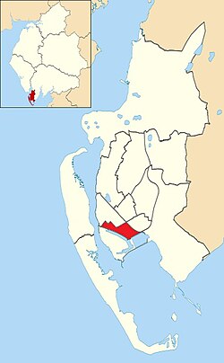
 Central Barrow shown within Barrow-in-Furness Central Barrow shown within Barrow-in-Furness | |
| Population | 4,583 (2011) |
| Unitary authority | |
| Shire county | |
| Region | |
| Country | England |
| Sovereign state | United Kingdom |
| Post town | BARROW-IN-FURNESS |
| Postcode district | LA |
| Dialling code | 01229 |
| Police | Cumbria |
| Fire | Cumbria |
| Ambulance | North West |
| UK Parliament | |
Central Barrow refers both to the town centre of Barrow-in-Furness, Cumbria, England and to the former electoral ward that roughly covers the eastern part of that town centre. In 2001 5,584 (ranking 5th out of 13) lived in the Central ward. The population density was 55.96 per hectare, which was well above the local average of 9.24, and England average, 3.77. The population of Central ward had reduced to 4,583 at the 2011 Census.
Central Barrow is amongst the 3% most deprived areas in the country and households have an average weekly income around £100 lower than the region's average, however the area being the central business district of the town is also home to many of Barrow's retail outlets, as well as a large amount of offices, restaurants and governmental buildings. Part of the £200 million Waterfront Barrow-in-Furness project is being constructed in the southern part of Central Barrow (including the new Marina Village).
The ward itself was combined with Barrow Island and Hindpool wards in April 2023 following formation of the new Westmorland and Furness Local Authority and be named 'Old Barrow'.
In a bid to tackle issues related with Central Barrow such as deprivation, unemployment and poor housing quality/choice, Barrow Borough Council is currently preparing the 'Central Barrow Masterplan' which will set out guidelines for the redevelopment of Central Barrow. The plan will also put forward proposals for a bus station/transport interchange to replace the existing shelters outside of the town hall. It is not yet known when the plan will be published or what exactly it will include.
Demographics
| Vital statistics | Central Barrow | Barrow-in-Furness | England |
|---|---|---|---|
| Religious individuals | 75.72% | 81.61% | 77.71% |
| Non-religious individuals | 15.52% | 10.79% | 14.59% |
| Religion withheld | 9.08% | 7.59% | 7.69% |
| Individuals in fairly good to good health |
81.20% | 86.75% | 90.97% |
| Individuals in bad health | 18.80% | 13.25% | 9.03% |
| People aged 16–74 who are economically active |
54.88% | 60.84% | 66.87% |
| People aged 16–74 who aren't economically active |
45.12% | 39.16% | 33.13% |
| People aged 16–74 with no qualifications |
41.34% | 32.82% | 28.85% |
See also
References
- Neighbourhood Statistics
- Neighbourhood Statistics
- "Barrow-in-Furness Ward population 2011". Retrieved 25 January 2016.
- Neighbourhood Statistics
- Central Barrow: Key Figures for 2001 Census
54°07′N 3°13′W / 54.11°N 3.22°W / 54.11; -3.22
| Districts and wards of the former Borough of Barrow-in-Furness | |
|---|---|
| Main settlements | |
| Districts | |
| Wards | |