Commune in Centre-Val de Loire, France
| Chambon | |
|---|---|
| Commune | |
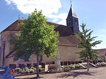
 The church of Saint-Pierre, in Chambon The church of Saint-Pierre, in Chambon | |
| Location of Chambon | |
  | |
| Coordinates: 46°47′16″N 2°19′32″E / 46.7878°N 2.3256°E / 46.7878; 2.3256 | |
| Country | France |
| Region | Centre-Val de Loire |
| Department | Cher |
| Arrondissement | Saint-Amand-Montrond |
| Canton | Trouy |
| Intercommunality | CC Arnon Boischaut Cher |
| Government | |
| • Mayor (2020–2026) | Maryse Jacquin-Salomon |
| Area | 13.91 km (5.37 sq mi) |
| Population | 158 |
| • Density | 11/km (29/sq mi) |
| Time zone | UTC+01:00 (CET) |
| • Summer (DST) | UTC+02:00 (CEST) |
| INSEE/Postal code | 18046 /18190 |
| Elevation | 147–187 m (482–614 ft) (avg. 170 m or 560 ft) |
| French Land Register data, which excludes lakes, ponds, glaciers > 1 km (0.386 sq mi or 247 acres) and river estuaries. | |
Chambon (French pronunciation: [ʃɑ̃bɔ̃] ) is a commune in the Cher department in the Centre-Val de Loire region of France.
Geography
The town was a part of the canton of Châteauneuf-sur-Cher; in 2015, following the redistribution of the cantons of the department, it became a part of the canton of Trouy.
Location

|
Saint-Symphorien | Crézançay-sur-Cher | 
| |
| Ineuil | N | Vallenay | ||
| W Chambon E | ||||
| S | ||||
| Morlac |
Typology
Chambon is a rural commune. It is a part of the municipalities with little or very little density, within the meaning of the municipal density grid of INSEE.
In addition, the municipality is part of the attraction area of Saint-Amand-Montrond, of which it is a municipality in the crown. This area, which includes 36 municipalities, is categorized into areas with fewer than 50,000 inhabitants.
Land use
The zoning of the municipality, as reflected in the database European occupation biophysical soil Corine Land Cover (CLC), is marked by the importance of the agricultural land (89.5% in 2018), a proportion roughly equivalent to that of 1990 (89.4%). The detailed breakdown in 2018 is as follows:
- grasslands (46.4%)
- arable land (43.1%)
- forests (10.5%)
Politics and administration
| Period | Name | |
|---|---|---|
| The missing data must be completed. | ||
| March 2001 | March 2008 | Louis Legrand |
| March 2008 | January 2010 | Gerard Lucas |
| February 2010 | 2014 | Jean-Marie Brochard |
| April 2014 | In progress | Maryse Jacquin-Salomon |
Environmental policy
In its 2016 winners, the National Council of Flowered Cities and Villages of France awarded one flower to the municipality in Concours des villes et villages fleuris.
Population
| Year | Pop. | ±% |
|---|---|---|
| 1962 | 215 | — |
| 1968 | 231 | +7.4% |
| 1975 | 195 | −15.6% |
| 1982 | 143 | −26.7% |
| 1990 | 122 | −14.7% |
| 1999 | 134 | +9.8% |
| 2008 | 148 | +10.4% |
Sights

The Church of Saint-Pierre de Chambon has been listed as a historical monument since 1922.
See also
References
- "Répertoire national des élus: les maires" (in French). data.gouv.fr, Plateforme ouverte des données publiques françaises. 13 September 2022.
- "Populations légales 2021" (in French). The National Institute of Statistics and Economic Studies. 28 December 2023.
- "Décret n° 2014-206 du 21 février 2014 portant délimitation des cantons dans le département du Cher". www.legifrance.gouv.fr. Archived from the original on 6 May 2021. Retrieved 25 July 2021.
- "Zonage rural | L'Observatoire des Territoires". www.observatoire-des-territoires.gouv.fr. Retrieved 25 July 2021.
- "Définition - Commune urbaine | Insee". www.insee.fr. Retrieved 25 July 2021.
- "Comprendre la grille de densité | L'Observatoire des Territoires". www.observatoire-des-territoires.gouv.fr. Archived from the original on 17 April 2021. Retrieved 25 July 2021.
- "Base des aires d'attraction des villes 2020 | Insee". www.insee.fr. Retrieved 25 July 2021.
- "En France, neuf personnes sur dix vivent dans l'aire d'attraction d'une ville - Insee Focus - 211". www.insee.fr. Retrieved 25 July 2021.
- "CORINE Land Cover | Données et études statistiques". archive.wikiwix.com. Retrieved 25 July 2021.
- "Résultats élections municipales 2020 : Chambon | Le Télégramme". elections.letelegramme.fr. Retrieved 25 July 2021.
- "Labeled municipalities". villes-et-villages-fleuris. Archived from the original on 20 February 2019.
- "Eglise Saint-Pierre". www.pop.culture.gouv.fr. Retrieved 25 July 2021.