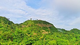
Chandranath Hill is the highest peak of Chittagong western hill range. The Chittagong Western Hill Range is the eastern part of the Himalayas separated from the Himalayas. This hill goes south and south-east of the Himalayas and crosses the Feni River through Assam and Tripura states of India and joins Chittagong District, Bangladesh. From the Feni river to the Chittagong city, it is about 70 kilometers long. Sitakunda Eco Park is built on the foothills of this hill.
Height and Peak
Chandranath Peak situated in the Western range of Chittagong is about 1152 feet (around) high and is the highest point in Chittagong District. Ambernama height is 900 feet and Saijjydala height is 801 feet. Chittagong North-Western Range The elevation decreases near the Karnaphuli River in Chittagong City . Batali Hill on the outskirts of Chittagong city is 280 feet high and Nangarkhana a little north of the city is 298 feet high.
Waterfalls and fountain

There are two waterfalls named Sahasradhara and Suptadhara. there are many more fountains and waterfalls, From this hill on the east, some of the fountains and canals have been gathered in the halda river. Among them, Ghazaria, Bermasia, Fatikchari, Harulalchari and Boalia is the main. On the west, Mahamaya, Mitha Chhara and many other canal and waterfalls have fallen into the Bay of Bengal. Now a rubber dam is built on Mahamaya canal. It is the second-largest man-made lake in Bangladesh after Kaptai Lake.
Gallery
References
- "Ecopark". Banglapedia. Retrieved 2021-07-11.
- চন্দ্রনাথের পাহাড় চূড়ায় ‘তীর্থস্থান’ ['Pilgrimage' on the top of Chandranath Hill]. Banglanews24.com (in Bengali). 2018-09-08. Retrieved 22 January 2019.
- ঘুরে আসুন চন্দ্রনাথের চূড়ায় [Visit Chandranath peak]. Bangla Tribune (in Bengali). Retrieved 22 January 2019.
- পর্যটকদের জন্য প্রস্তুত মহামায়া লেক [Mahamaya Lake is ready for tourists]. Jugantor (in Bengali). Archived from the original on 4 August 2013. Retrieved 22 January 2019.
External links
Categories:


