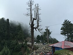
Town in Khyber-Pakhtunkhwa, Pakistan
| Changla Gali | |
|---|---|
| Town | |
 | |
 | |
| Coordinates: 33°59′18.63″N 73°23′17.91″E / 33.9885083°N 73.3883083°E / 33.9885083; 73.3883083 | |
| Country | |
| Province | Khyber-Pakhtunkhwa |
| District | Abbottabad District |
| Elevation | 2,804 m (9,199 ft) |
| Time zone | UTC+5 (PST) |
Changla Gali is one of the tourist mountain resort towns of the Galyat area of Pakistan. It has an elevation of 2804m. During British rule it was the headquarters of the Northern Command School of Musketry.
Location
Changla Gali is located in Seer Gharbi which is a Union Council of Abbottabad District, and is located 16 km north from the more famous Galyat town of Murree in Rawalpindi District.
References
- ^ Changlagali – Government of the Punjab Archived 8 December 2007 at the Wayback Machine
- Changlagali – Imperial Gazetteer of India 1908, v10, p173
This Abbottabad District location article is a stub. You can help Misplaced Pages by expanding it. |