| Changshaoying Manchu Ethnic Township
长哨营满族乡 ᠴᠠᠩ ᡧᠣᠣ ᠶᡝᠩ ᠮᠠᠨᠵᡠ ᡠᡴᠰᡠᡵᠠᡳ ᡤᠠᡧᠠᠨ | |
|---|---|
| Ethnic Township | |
 Zhaojiawan Agricultural Park within the town, 2012 Zhaojiawan Agricultural Park within the town, 2012 | |
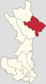
 Location in Huairou District Location in Huairou District | |
  | |
| Coordinates: 40°47′34″N 116°44′35″E / 40.79278°N 116.74306°E / 40.79278; 116.74306 | |
| Country | China |
| Municipality | Beijing |
| District | Huairou |
| Village-level Divisions | 24 villages |
| Area | |
| • Total | 249.6 km (96.4 sq mi) |
| Elevation | 349 m (1,145 ft) |
| Population | |
| • Total | 5,378 |
| • Density | 22/km (56/sq mi) |
| Time zone | UTC+8 (China Standard) |
| Postal code | 101412 |
| Area code | 010 |
Changshaoying Manchu Ethnic Township (simplified Chinese: 长哨营满族乡; traditional Chinese: 長哨營滿族鄉; pinyin: Chángshàoyíng Mǎnzú Xiāng) is an ethnic township situated in the northeastern portion of Huairou District, Beijing, China. It borders Hushiha Town in its northeast, Maquanzi Village in its east, Majiayu Town in its southeast, Tanghekou Town in its southwest, and Labagoumen Manchu Ethnic Township in its northwest. It had a population of 5,378 as of 2020. The name Changshaoying literally translates to "Long Whistle Barrack".
History
| Year | Status | Within |
|---|---|---|
| 1908 - 1913 | Luanping County, Chengde Prefecture | |
| 1913 - 1937 | Luanping County, Rehe | |
| 1937 - 1945 | Under Manchukuo | |
| 1945 - 1947 | 11th District | Luanping County, Rehe |
| 1947 - 1952 | Sihai County, Rehe | |
| 1952 - 1956 | 7th District | Huairou County, Hebei |
| 1956 - 1958 | Changshaoying Township
Beiwanzi Township | |
| 1958 - 1960 | Changshaoying Management Area, Gangtie People's Commune | Huairou County, Beijing |
| 1960 - 1961 | Qingshiling People's Commune | |
| 1961 - 1983 | Changshaoying People's Commune | |
| 1983 - 1998 | Changshaoying Township | |
| 1998 - 2001 | Changshaiying Manchu Ethnic Township (Merged with Qidaohe Manchu Ethnic Township in 1998) | |
| 2001–present | Huairou District, Beijing |
Administrative divisions
In 2021, Changshaoying Manchu Ethnic Township oversaw 24 villages under its administration:
| Subdisvision Names | Name Transliterations |
|---|---|
| 东南沟 | Dongnangou |
| 老西沟 | Laoxigou |
| 长哨营 | Changshaoying |
| 遥岭 | Yaoling |
| 杨树湾 | Yangshuwan |
| 二道河 | Erdaohe |
| 三岔口 | Sanchakou |
| 大地 | Dadi |
| 榆树湾 | Yushuwan |
| 古洞沟 | Gudonggou |
| 七道梁 | Qidaoliang |
| 北湾 | Beiwan |
| 东辛店 | Dongxindian |
| 北干沟 | Beigangou |
| 四道河 | Sidaohe |
| 大沟 | Dagou |
| 项栅子 | Xiangzhazi |
| 七道河 | Qidaohe |
| 八道河 | Badaohe |
| 西沟 | Xigou |
| 后沟 | Hougou |
| 上孟营 | Shangmengying |
| 老沟门 | Laogoumen |
| 三道窝铺 | Sandaowopu |
See also
References
- "北京市怀柔区第七次全国人口普查公报_重点工作_怀柔区人民政府网站". www.bjhr.gov.cn. Retrieved 2022-10-24.
- 李立国; 李万钧; 吴世民, eds. (2013). 中华人民共和国政区大典, 北京市卷. Beijing: 中国社会出版社. ISBN 978-7-5087-4058-4. OCLC 910451741.
- "2021年统计用区划代码和城乡划分代码". www.stats.gov.cn. Retrieved 2022-10-26.
| Subdivisions of Huairou District, Beijing | |
|---|---|
| Subdistricts | |
| Areas/Towns | |
| Towns | |
| Ethnic Townships | |
| Analogous township level unit | |
This Beijing location article is a stub. You can help Misplaced Pages by expanding it. |