| Cheshire Bridge | |
|---|---|
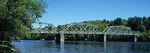
 1930 Cheshire Bridge over the Connecticut River 1930 Cheshire Bridge over the Connecticut River | |
| Coordinates | 43°15′38″N 72°25′38″W / 43.260452°N 72.427319°W / 43.260452; -72.427319 |
| Carries | 2 lanes of roadway trains (until 1984) |
| Crosses | Connecticut River |
| Characteristics | |
| Design | three-span Pennsylvania truss |
| Total length | 489 feet (149 m) |
| History | |
| Constructed by | McClintic-Marshall Co. |
| Construction end | 1806, 1906, 1930 |
| Construction cost | US$225,000 (US$4,100,000 with inflation) |
| Opened | 1930 |
| Statistics | |
| Toll | none since 2001 |
| Location | |
The Cheshire Bridge spans the Connecticut River between Charlestown, New Hampshire, and Springfield, Vermont.
History
The first bridge at this location was completed in 1806 by the Cheshire Bridge Co. and was described as a Town lattice covered toll bridge, a wooden covered bridge. In 1897 the bridge was purchased by the Springfield Electric Railway.
In 1906 the old bridge was replaced by the Iron Bridge Co., at a cost of US$65,000 (US$2,200,000 with inflation). It was a three-span steel Pratt truss bridge, which had a 600-foot (180 m) span and a 20-foot (6.1 m)-wide roadway. Vehicles ran both ways, and also freight and passenger cars. In 1930 the bridge was replaced by the McClintic-Marshall Co. of Pittsburgh, Pennsylvania, at a cost of US$225,000 (US$4,100,000 with inflation). It is a three-span Pennsylvania truss that is 489 feet (149 m) feet long.
The bridge was purchased by the state of New Hampshire in 1992. Tolls were collected until 2001.
References
- ^ 1634–1699: McCusker, J. J. (1997). How Much Is That in Real Money? A Historical Price Index for Use as a Deflator of Money Values in the Economy of the United States: Addenda et Corrigenda (PDF). American Antiquarian Society. 1700–1799: McCusker, J. J. (1992). How Much Is That in Real Money? A Historical Price Index for Use as a Deflator of Money Values in the Economy of the United States (PDF). American Antiquarian Society. 1800–present: Federal Reserve Bank of Minneapolis. "Consumer Price Index (estimate) 1800–". Retrieved February 29, 2024.
- "Cheshire Bridge". Bridgehunter.com. Retrieved 9 August 2014.
- John Farmer; Jacob Bailey Moore (1823). A gazetteer of the state of New-Hampshire, by J. Farmer and J.B. Moore. pp. 94–.
- Henry Hamilton Saunderson (1876). History of Charlestown, New Hampshire: The Old No. 4, Embracing the Part Borne by Its Inhabitants in the Indian, French and Revolutionary Wars, and the Vermont Controversy; Also Genealogies and Sketches of Families, from Its Settlement to 1876. Claremont Manufacturing Company. pp. 685–.
- "Cheshire Bridge". Connecticut River Bridges.
- Glenn A. Knoblock (25 January 2012). Historic Iron and Steel Bridges in Maine, New Hampshire and Vermont. McFarland. pp. 182–. ISBN 978-0-7864-8699-1.
- "New Hampshire Eliminates Connecticut River Toll". Trucking Info.
External links
| Crossings of the Connecticut River | ||||
|---|---|---|---|---|
| ||||
- Bridges in Sullivan County, New Hampshire
- Railroad bridges in Vermont
- Railroad bridges in New Hampshire
- Charlestown, New Hampshire
- Buildings and structures in Springfield, Vermont
- Bridges over the Connecticut River
- Bridges in Windsor County, Vermont
- Former toll bridges in New Hampshire
- Former toll bridges in Vermont
- Steel bridges in the United States
- Pennsylvania truss bridges in the United States
- Road bridges in Vermont
- Road bridges in New Hampshire
- Interstate vehicle bridges in the United States
- 1930 establishments in New Hampshire
- 1930 establishments in Vermont