| Chetr Borei ស្រុកចិត្របុរី | |
|---|---|
| District (srok) | |
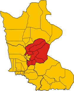
 District location in Kratié province District location in Kratié province | |
| Coordinates: 12°28′4.9″N 106°10′27.2″E / 12.468028°N 106.174222°E / 12.468028; 106.174222 | |
| Country | |
| Province | Kratié |
| Communes | 10 |
| Villages | 58 |
| Time zone | UTC+07:00 (ICT) |
| Geocode | 1006 |
Chetr Borei (Khmer: ស្រុកចិត្របុរី), lit. 'The Artisan city' is a district of Kratié province, Cambodia.
Administration
The district is subdivided into 10 communes (khum).
Communes and villages
| Khum (commune) | Phum (villages) |
|---|---|
| Bos Leav | Bos Leav Kraom, Bos Leav Leu, Lvea Tong, Preah Konlong, Preaek Kov, Preaek Ta Am, Preaek Ta Thoeng, Ta Luh |
| Changkrang | Changkrang, Kasang |
| Dar | Anhchanh, Chuor Chrey, Dar, Khnang Pos, Khsar, Mreum, Sereipheap, Stueng Svay, Ta Nguon |
| Kantuot | a Loch, Antong Vien, Chrava, Kantuot, Srae Non |
| Kou Loab | Banteay, Chrava, Kambaor, Kou Loab, Samret |
| Kaoh Chraeng | Kandal, Kbal Kaoh, Preaek, Roka Knaor, Voat |
| Sambok | Boeng Run, Kakot, Kbal Chuor, Smabok, Srae Haen |
| Thma Andaeuk | Chuor Krouch, Damnak Sasar, L'ak, Sampong, Serei Sokha, Srae Doung |
| Thma Kreae | Ruessei Char, Thma Krae Kandal, Thma Krae Leu |
| Thmei | Chranaol, Khnach, Krasang, Mean Chey, B'ier, Svay Chrum, Thmei, Tnaot, Treab, Veal Sambour |
References
- "Map 10. Administrative Areas in Kratie Province by District and Commune" (PDF). National Institute of Statistics, Ministry of Planning (Cambodia). 2013-12-31.
External links
| Capital: Kratié | ||
| Districts |  | |
| Autonomous municipality |
| ||||||||||||||||||||||||||||||||||||||||||||||||||
|---|---|---|---|---|---|---|---|---|---|---|---|---|---|---|---|---|---|---|---|---|---|---|---|---|---|---|---|---|---|---|---|---|---|---|---|---|---|---|---|---|---|---|---|---|---|---|---|---|---|---|---|
| Provinces |
| ||||||||||||||||||||||||||||||||||||||||||||||||||
This Cambodian location article is a stub. You can help Misplaced Pages by expanding it. |