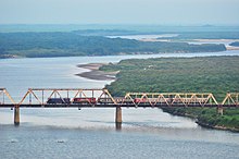

The China–North Korea–Russia tripoint is the tripoint where the China–Russia border and the North Korea–Russia border intersect. The tripoint is in the Tumen River about 500 meters upstream from Korea Russia Friendship Bridge and under 2,000 meters from the Russian settlement of Khasan.

Markers
Three granite shoreside markers, which are in effect triangulation stations, are specified in the 1985 treaty defining the tripoint, which is "a straight line running along the perpendicular from border sign No. 423 on the Russian-Chinese state border to the line of the middle of the main channel of the Tumannaya River between both banks of the river."
- Boundary marker no. 423, Russia–China border (treaty number 1; left bank) - 42°25′10.2″N 130°38′17.7″E / 42.419500°N 130.638250°E / 42.419500; 130.638250 (Boundary marker no. 423 (Pyongyang)) (Pyongyang datum) 42°25′11″N 130°38′21″E / 42.419787°N 130.639275°E / 42.419787; 130.639275 (Boundary marker no. 423 (WGS-84)) (WGS-84)
- Korea marker (treaty number 2; right bank) - 42°24′59.5″N 130°38′06.5″E / 42.416528°N 130.635139°E / 42.416528; 130.635139
- Russia marker (treaty number 3; left bank) - coordinates to be amended
Description
The terrestrial boundary between Russia and North Korea runs along the fairway (thalweg) of the Tumen River and its estuary, whist the maritime boundary separates the two countries' territorial waters in the Sea of Japan.
The principal border treaty was signed on April 17, 1985. A separate, trilateral treaty specifies the position of the tripoint of the borders of Russia, North Korea, and China. The North Korea–Russia and China–North Korea borders run along the middle of the Tumen River, whilst the China–Russia border approaches the junction point overland from the north. Because the theoretical tripoint is in the middle of the river, where it would be impractical to install a border monument, the protocol is that the three countries install border monuments on the riverbank, and that the position of the tripoint be determined with respect to the monuments themselves. The Chinese trig station is popular with Chinese tourists, affording as it does a view of their destitute ally North Korea.
The administrative unit on the Russian side of the border is the Khasansky District of Primorsky Krai, on the Korean side, the city of Rason, and on the Chinese side Fangchuan. The main Russian border guard station in the area is Peschanaya.
Border line vis-a-vis border zone
One interpretation of various treaties is that a China–North Korea border zone exists in the river (or even an international condominium), in which case there would not be a point where all three countries' sovereign territory meet.
References
- "Journey to North Korean Border 🇰🇵". February 11, 2022 – via YouTube.
- ^ Информация о международных соглашениях ("Information on international agreements") Archived July 8, 2015, at the Wayback Machine (in Russian)
- Северная Корея ("North Korea") Archived July 7, 2015, at the Wayback Machine, at the Russia's border agency's (Rosgranitsa) official site (in Russian)
- ^ Соглашение между Правительством Российской Федерации, Правительством Китайской Народной Республики и Правительством Корейской Народно-Демократической Республики об определении линии разграничения пограничных водных пространств трех государств на реке Туманная [Agreement between the Government of the Russian Federation, the Government of the People's Republic of China, and the Government of the People's Democratic Republic of Korea, determining the line of delimitation of the water spaces of the three states on the Tumen River] (in Russian). Federal Agency for the Development of State Border Infrastructure. Archived from the original on 2015-07-02. Retrieved April 23, 2018.
- "China watching North Korea's friendship with Russia". www.bbc.com.
- Lee & Shin 2013, p. 111.
- Rolf Palmberg (2013), China - North Korea - Russia tripoint, International Border Research Group
Sources
- Lee, Seok-Woo; Shin, Chang-Hoon (2013), "Implications of the border regime between North Korea and China", in Paek, C.; Paik, J.H.; Yi, S.; Lee, S.W.; Tan, K. (eds.), Asian Approaches to International Law and the Legacy of Colonialism: The Law of the Sea, Territorial Disputes and International Dispute Settlement, Routledge research in international law, Routledge, pp. 109–118, ISBN 978-0-415-67978-7
Further reading
- Frank Jacobs (February 21, 2012), "Manchurian Trivia", The New York Times
- Gomà Pinilla, Daniel (March–April 2004), "Border Disputes between China and North Korea: The Yalu and Tumen Rivers, and control of the seas", China Perspectives, 2004 (52), translated by Peter Brown from the French original, doi:10.4000/chinaperspectives.806 – via Open Edition
- China's Territorial and Boundary Affairs – Protocol on Tri-junction of the Boundary between and among China, North Korea and Russia in the Tumen River on June 20, 2002 at the Wayback Machine (archived 2011-07-23) at PRC Ministry of Foreign Affairs
- Rongxing Guo (2009), Land and maritime boundary disputes of Asia, Nova Science, ISBN 9781607416296, item China-Korea (North)-Russia tripoint
42°25′06″N 130°38′13″E / 42.41833°N 130.63701°E / 42.41833; 130.63701
| Borders of Russia | |
|---|---|
| Land: |
|
| Maritime: | |
| Borders of China | |
|---|---|
| International: | |
| Internal: | |
| Borders of North Korea | |
|---|---|