Human settlement in England
| Chop Gate | |
|---|---|
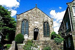
 Chop Gate Methodist Church Chop Gate Methodist Church | |
 | |
| OS grid reference | SE 5594 9986 |
| Unitary authority | |
| Ceremonial county | |
| Region | |
| Country | England |
| Sovereign state | United Kingdom |
| Post town | Middlesbrough |
| Postcode district | TS9 |
| Police | North Yorkshire |
| Fire | North Yorkshire |
| Ambulance | Yorkshire |
| UK Parliament | |
| 54°23′28″N 1°08′24″W / 54.391171°N 1.1399699°W / 54.391171; -1.1399699 | |
Chop Gate (/ˌtʃɒp ˈjæt/ CHOP YAT) is a small village in the North York Moors national park, North Yorkshire, England. Historically part of the North Riding of Yorkshire, the village is situated 7.5 miles (12 km) south east of Stokesley and 12.5 miles (20 km) north of Helmsley.
The village is at the point where the roads to Bilsdale and Raindale meet. Chop Gate is on the B1257 road between Helmsley and Stokesley.
See also
References
- Moss, John (2020). History of english place names and where they came from. Barnsley: Pen & Sword. p. 344. ISBN 978-1-52672-284-3.
- Ordnance Survey: Landranger map sheet 100 Malton & Pickering (Helmsley & Easingwold) (Map). Ordnance Survey. 2012. ISBN 9780319231203.
- "Ordnance Survey: 1:50,000 Scale Gazetteer" (csv (download)). www.ordnancesurvey.co.uk. Ordnance Survey. 1 January 2016. Retrieved 18 February 2016.
- "Genuki: Helmsley Supplementary, Yorkshire (North Riding)". genuki.org.uk. Retrieved 8 March 2024.
- Chrystal, Paul (2017). The Place Names of Yorkshire; Cities, Towns, Villages, Rivers and Dales, some Pubs too, in Praise of Yorkshire Ales (1 ed.). Catrine: Stenlake. p. 25. ISBN 9781840337532.
This Hambleton, North Yorkshire location article is a stub. You can help Misplaced Pages by expanding it. |