| This article needs additional citations for verification. Please help improve this article by adding citations to reliable sources. Unsourced material may be challenged and removed. Find sources: "Churchville, Brampton" – news · newspapers · books · scholar · JSTOR (March 2011) (Learn how and when to remove this message) |
| Churchville | |
|---|---|
| Unincorporated community | |
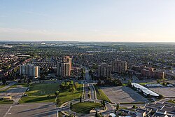
 Aerial view of Churchville in 2021 Aerial view of Churchville in 2021 | |
| Coordinates: 43°37′48″N 79°45′20″W / 43.63000°N 79.75556°W / 43.63000; -79.75556 | |
| Country | Canada |
| Province | Ontario |
| Regional municipality | Peel |
| City | Brampton |
| Founded | 1815 |
| Time zone | UTC-5 (EST) |
| • Summer (DST) | UTC-4 (EDT) |
| Forward sortation area | List of L postal codes of Canada |
| Area code(s) | 905 and 289 |
| NTS Map | 030M12 |
| GNBC Code | FAQWC |
Churchville is a preserved suburban hamlet in the south-west corner of Brampton, Ontario, Canada. The village was designated as a heritage conservation district under the Ontario Heritage Act in 1990, making it Brampton's only heritage conservation district.
History

Churchville was founded in 1815 by Amaziah Church (1766-1831), who built a gristmill on the Credit River in what was then Toronto Township, York County (Peel County was created from York County in 1851). This small area surrounding the mill on the floodplain of the river valley was where the original settlement was focused.
Over the course of its history, the village grew to include homes, a slaughterhouse, a tannery, a school house, a wooden sidewalk, several churches and small hotels and a cemetery. Many of these structures no longer exist, although some houses have survived from Churchville's early period, and are designated heritage houses.
Churchville, along with the northern extremities of Mississauga (which Toronto Township was restructured into in 1967), were amalgamated into the enlarged City of Brampton on 1 January 1974 as part of the restructuring of Peel County into the Regional Municipality of Peel.
In 2022, flooding occurred due to an ice jam, which damaged around 50 homes. The mayor, Patrick Brown visited the community, and around 100 homes were evacuated. The city has spent $345 thousand dollars studying the flood.
Notes
- "Churchville Heritage Conservation District". www1authoring.brampton.ca. Retrieved 6 December 2023.
- ^ From his tombstone in Churchville Cemetery.
- ^ "Churchville Celebrates Its Bicentennial (1815-2015)" (PDF). The Brampton Heritage Times. 2016. p. 1. Retrieved 7 December 2023.
- ^ Ryan, Rocca (17 February 2022). "Flooding in Brampton community prompts evacuation, around 100 homes affected". Global News. Retrieved 7 December 2023.
- Rumbolt, Ryan (23 February 2022). "Brampton residents face massive clean up after Churchville flood | inBrampton". insauga | Local Online News. Retrieved 8 December 2023.
- Morgan, Rachel (24 May 2023). "Brampton reflects on damaging Churchville flood while PCs make it easier to build in floodplains". The Pointer. Retrieved 18 June 2024.
External links
- "Churchville". nrcan.gc.ca. Geographical Names, Natural Resources Canada. Retrieved 5 December 2017.
- Marshall, Sean (5 February 2010). "GTA's Lost Villages: Churchville". spacingtoronto.ca. Archived from the original on 10 April 2012.
- Arora, Team (29 April 2023). "Living in Churchville, Brampton".
43°37′48″N 79°45′20″W / 43.63000°N 79.75556°W / 43.63000; -79.75556
| Brampton | |
|---|---|
| Buildings and structures |
|
| Neighborhoods | |
| Organizations | |
| Education | |
| Politics | |
| Media |
|
| Events | |
| Geography | |
| Transportation | |
This Ontario geographical article about a location in the Golden Horseshoe is a stub. You can help Misplaced Pages by expanding it. |