| Cinajara | |
|---|---|
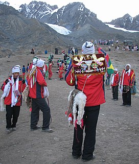
 Quyllur Rit'i festival at the foothills of Cinajara and Jolljepunco Quyllur Rit'i festival at the foothills of Cinajara and Jolljepunco | |
| Highest point | |
| Elevation | 5,471 m (17,949 ft) |
| Coordinates | 13°31′42″S 71°14′01″W / 13.52833°S 71.23361°W / -13.52833; -71.23361 |
| Geography | |
 | |
| Location | Peru, Cusco Region |
| Parent range | Andes, Vilcanota |
| Climbing | |
| First ascent | 1-1979 via S.E. ridge. |
Cinajara or Sinaqara is a mountain in the Vilcanota mountain range in the Andes of Peru, about 5,471 metres (17,949 ft) high. It is situated in the Cusco Region, Quispicanchi Province, in the districts Ccarhuayo and Ocongate. Cinajara lies southwest of the Jolljepunco. The annual religious Quyllur Rit'i festival takes place at the foot of the mountains Cinajara and Jolljepunco.
References
- ^ Peru 1:100 000, Ocongate (28-t). IGN (Instituto Geográfico Nacional - Perú).
- Jill Neate, Mountaineering in the Andes, Peru: "Cinajara 5471m, P.5310m: N. of Ocongate: 1-1979 via S.E. ridge."
- ^ Busch, Oskar E. (2001). Peru für Trekker und Bergsteiger: 56 Wanderungen und 11 Bergbesteigungen in den peruanischen Anden (in German). Bergverlag Rother GmbH. p. 263. ISBN 9783763327058.
- La civilización andina: nuevo enfoque científico, filosófico y tecnológico (in Spanish). Academia Mayor de la Lengua Quechua. 2006. p. 119.
- Millones, Luis; Ōnuki, Yoshio (1994). El mundo ceremonial andino (in Spanish). Editorial Horizonte. p. 303.
- escale.minedu.gob.pe - UGEL map of the Quispicanchi Province 1 (Cusco Region) showing "Nevado Cinajara"
This Cusco Region geography article is a stub. You can help Misplaced Pages by expanding it. |