| Clark Mountain | |
|---|---|
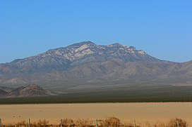
 The mountain is prominently visible to motorists on Interstate 15 crossing Ivanpah Dry Lake. The mountain is prominently visible to motorists on Interstate 15 crossing Ivanpah Dry Lake. | |
| Highest point | |
| Elevation | 7,933 ft (2,418 m) NAVD 88 |
| Prominence | 4,232 ft (1,290 m) |
| Listing | Desert Peaks Section List |
| Coordinates | 35°31′32″N 115°35′19″W / 35.525569794°N 115.588717936°W / 35.525569794; -115.588717936 |
| Geography | |
| Location | San Bernardino County, California, U.S. |
| Parent range | Clark Mountain Range |
| Topo map | USGS Clark Mountain |
| Climbing | |
| Easiest route | Exposed scramble, class 3 |
Clark Mountain is a mountain located in the Clark Mountain Range in the Mojave National Preserve, close to the California-Nevada border.
Geography
The mountain rises abruptly north of Mountain Pass and Interstate 15 to an elevation of 7,933 ft (2,418 m), which is the highest point of the Mojave National Preserve and the Mojave Desert ranges.
Path 46 and Path 64 (part of Path 46) 500 kV power lines run to the north and south of the mountain, respectively.
Ecology
The higher elevations of the mountain are a striking sky island contrast to the lower elevations of the Mojave Desert vegetation. Creosote bush (Larrea tridentata), scrub and Joshua tree (Yucca brevifolia) forests grow on the foothills of the mountain while single-leaf pinyon pine (Pinus monophylla), Utah juniper (Juniperus osteosperma), and white fir (Abies concolor) grow on the sky island at the highest elevations.
The high elevation of the mountain means that snow falls on the high peaks during the winter, although the mountain receives little precipitation annually.
Recreation
Clark Mountain is also a world-class rock climbing area developed by Randy Leavitt in 1992. It has been described as containing the best limestone climbing in America and includes the world's first-ever 9b (5.15b) route, Chris Sharma's Jumbo Love (2008). In 2022, French climber Seb Bouin, added a direct start to Jumbo Love to create Suprême Jumbo Love, which at 9b+ (5.15c), became the hardest sport climb in North America.
See also
References
- ^ "Clark". NGS Data Sheet. National Geodetic Survey, National Oceanic and Atmospheric Administration, United States Department of Commerce. Retrieved 2009-06-29.
- "Clark Mountain, California". Peakbagger.com. Retrieved 2009-06-29.
- ^ "Desert Peaks Section List" (PDF). Angeles Chapter, Sierra Club. Retrieved 2010-01-03.
- Clark Mountain quadrangle, California (Map). 1:24000. 7.5 Minute Topographic. USGS. Retrieved 2010-01-03.
- ^ Google Earth images.
- ^ "Subsection 322Aj - Kingston Range - Valley Wells". USDA, Forest Service. Archived from the original on 2005-03-13. Retrieved 2007-12-18.
- Leavitt, Randy. "Clark Mountain - the best limestone in America". UKClimbing.com. Retrieved 2010-01-03.
- Walsh, Anthony (3 November 2022). "Séb Bouin Just Established the Hardest Route in America (5.15c)". Climbing. Retrieved 18 November 2022.
- California road & recreation atlas (4th ed.). Medford, OR: Benchmark Maps. 2005. p. 97. ISBN 978-0-929591-80-3.
- Zdon, Andy (2000). Desert Summits: A Climbing & Hiking Guide to California and Southern Nevada. Bishop, CA: Spotted Dog Press. ISBN 1-893343-02-2.