| Tromøy Municipality Tromøy kommune | |
|---|---|
| Former municipality | |
| Tromø herred (historic name) | |
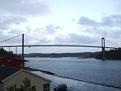
 View of Tromøy View of Tromøy | |
 Flag Flag Coat of arms Coat of arms | |
| Nickname: The pearl of Southern Norway | |
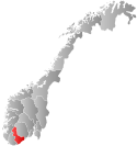
 Aust-Agder within Norway Aust-Agder within Norway | |
 Tromøy within Aust-Agder Tromøy within Aust-Agder | |
| Coordinates: 58°26′59″N 08°51′51″E / 58.44972°N 8.86417°E / 58.44972; 8.86417 | |
| Country | Norway |
| County | Aust-Agder |
| District | Østre Agder |
| Established | 1 May 1878 |
| • Preceded by | Østre Moland Municipality |
| Disestablished | 1 Jan 1992 |
| • Succeeded by | Arendal Municipality |
| Administrative centre | Brekka |
| Area | |
| • Total | 30 km (10 sq mi) |
| Population | |
| • Total | 4,711 |
| • Density | 160/km (410/sq mi) |
| Time zone | UTC+01:00 (CET) |
| • Summer (DST) | UTC+02:00 (CEST) |
| ISO 3166 code | NO-0921 |
| Data from Statistics Norway | |
Tromøy (historic: Tromø) is a former municipality in the old Aust-Agder county in Norway. The 30-square-kilometre (12 sq mi) municipality existed from 1878 until its dissolution in 1992. The municipal area is now part of the municipality of Arendal in Agder county. The administrative centre was the village of Brekka, where the historic Tromøy Church is located. The municipality encompassed all of the island of Tromøya as well as many smaller surrounding islands such as Merdø, Gjesøya, Skilsøy, and Tromlingene.
The municipality had two churches: the centuries-old Tromøy Church and the relatively new Færvik Church. Some of the main villages in Tromøy were Færvik, Brekka, Brattekleiv, Sandnes, Revesand, and Pusnes. The municipality was connected to the mainland by the Tromøy Bridge, the only road connection to Tromøya. The other islands of Tromøy were only accessible by boat.
History
The municipality of Tromøy was established on 1 May 1878 when the municipality of Østre Moland was divided into three municipalities: Tromøy (population: 2,320), Barbu (population: 4,874), and Østre Moland (population: 2,524). On 1 January 1992 there was a major municipal merger where the following municipalities were merged into the municipality of Arendal: Tromøy (population: 4,711), Moland (population: 8,148), Øyestad (population: 8,679), Hisøy (population: 4,026), and the town of Arendal (population: 12,478).
Name
The municipality (originally the parish) is named after the island of Tromøya (Old Norse: Þruma). The first element is likely derived from the word þrǫmr which means "rim", "edge", or "border". The last element is øy which means "island". Historically, the name of the municipality was spelled Tromø. On 3 November 1917, a royal resolution changed the spelling of the name of the municipality to Tromøy. The letter y was added to the end of the word to "Norwegianize" the name (ø is the Danish word for "island" and øy is the Norwegian word).
Coat of arms
The coat of arms was granted on 23 August 1985 and in use until the municipal merger on 1 January 1992. The official blazon is "Per fess nebuly argent and azure" (Norwegian: Delt av sølv og blått ved skysnitt). This means the arms have a field (background) that is divided in half horizontally with a nebuly line. The top part has a tincture of argent which means it is commonly colored white, but if it is made out of metal, then silver is used. The bottom part is colored blue. The design is meant to mimic the coastline near the village of Brekka, which is characterised by large rounded boulders protruding out into the sea. This landscape dates back to the Ice Age and was used to model the division line in the coat of arms. The arms are also canting since the name of the municipality is derived from the word "Trom" (Old Norse: Þroma) which means "edge" or "rim", referring to the division line on the arms and the boulders along the sea. The arms were designed by Anne Marie Falck.
Government
While it existed, this municipality was responsible for the primary education (through 10th grade), outpatient health services, senior citizen services, unemployment, social services, zoning, economic development, and municipal roads. During its existence, this municipality was governed by a municipal council of directly elected representatives. The mayor was indirectly elected by a vote of the municipal council.
Mayors
The mayors (Norwegian: ordfører) of Tromøy (incomplete list):
- 1919-1931: Søren Hans Smith Sørensen (H)
- 1932-1934: Christian Stray (V)
- 1934-1941: Søren Hans Smith Sørensen (H)
- 1945-1945: Søren Hans Smith Sørensen (H)
- 1956-1959: Christian Stray (V)
Municipal council
The municipal council (Kommunestyre) of Tromøy was made up of 21 representatives that were elected to four year terms. The tables below show the historical composition of the council by political party.
| Party name (in Norwegian) | Number of representatives | |
|---|---|---|
| Labour Party (Arbeiderpartiet) | 10 | |
| Conservative Party (Høyre) | 6 | |
| Christian Democratic Party (Kristelig Folkeparti) | 2 | |
| Socialist Left Party (Sosialistisk Venstreparti) | 1 | |
| Liberal Party (Venstre) | 2 | |
| Total number of members: | 21 | |
| Party name (in Norwegian) | Number of representatives | |
|---|---|---|
| Labour Party (Arbeiderpartiet) | 8 | |
| Progress Party (Fremskrittspartiet) | 1 | |
| Conservative Party (Høyre) | 7 | |
| Christian Democratic Party (Kristelig Folkeparti) | 3 | |
| Socialist Left Party (Sosialistisk Venstreparti) | 1 | |
| Liberal Party (Venstre) | 1 | |
| Total number of members: | 21 | |
| Party name (in Norwegian) | Number of representatives | |
|---|---|---|
| Labour Party (Arbeiderpartiet) | 7 | |
| Conservative Party (Høyre) | 8 | |
| Christian Democratic Party (Kristelig Folkeparti) | 3 | |
| Centre Party (Senterpartiet) | 1 | |
| Liberal Party (Venstre) | 2 | |
| Total number of members: | 21 | |
| Party name (in Norwegian) | Number of representatives | |
|---|---|---|
| Labour Party (Arbeiderpartiet) | 5 | |
| Conservative Party (Høyre) | 5 | |
| Christian Democratic Party (Kristelig Folkeparti) | 3 | |
| Joint list of the New People's Party (Nye Folkepartiet), Centre Party (Senterpartiet), and Liberal Party (Venstre) | 4 | |
| Total number of members: | 17 | |
| Party name (in Norwegian) | Number of representatives | |
|---|---|---|
| Labour Party (Arbeiderpartiet) | 7 | |
| Conservative Party (Høyre) | 4 | |
| Christian Democratic Party (Kristelig Folkeparti) | 3 | |
| Liberal Party (Venstre) | 3 | |
| Total number of members: | 17 | |
| Party name (in Norwegian) | Number of representatives | |
|---|---|---|
| Labour Party (Arbeiderpartiet) | 7 | |
| Conservative Party (Høyre) | 4 | |
| Christian Democratic Party (Kristelig Folkeparti) | 3 | |
| Liberal Party (Venstre) | 3 | |
| Total number of members: | 17 | |
| Party name (in Norwegian) | Number of representatives | |
|---|---|---|
| Labour Party (Arbeiderpartiet) | 8 | |
| Conservative Party (Høyre) | 4 | |
| Christian Democratic Party (Kristelig Folkeparti) | 2 | |
| Liberal Party (Venstre) | 3 | |
| Total number of members: | 17 | |
| Party name (in Norwegian) | Number of representatives | |
|---|---|---|
| Labour Party (Arbeiderpartiet) | 9 | |
| Conservative Party (Høyre) | 4 | |
| Liberal Party (Venstre) | 4 | |
| Total number of members: | 17 | |
| Party name (in Norwegian) | Number of representatives | |
|---|---|---|
| Labour Party (Arbeiderpartiet) | 8 | |
| Conservative Party (Høyre) | 5 | |
| Liberal Party (Venstre) | 4 | |
| Total number of members: | 17 | |
| Party name (in Norwegian) | Number of representatives | |
|---|---|---|
| Labour Party (Arbeiderpartiet) | 7 | |
| Conservative Party (Høyre) | 4 | |
| Liberal Party (Venstre) | 5 | |
| Total number of members: | 16 | |
| Party name (in Norwegian) | Number of representatives | |
|---|---|---|
| Labour Party (Arbeiderpartiet) | 6 | |
| Conservative Party (Høyre) | 5 | |
| Liberal Party (Venstre) | 5 | |
| Total number of members: | 16 | |
| Party name (in Norwegian) | Number of representatives | |
|---|---|---|
| Labour Party (Arbeiderpartiet) | 8 | |
| Conservative Party (Høyre) | 5 | |
| Joint list of the Liberal Party (Venstre) and the Radical People's Party (Radikale Folkepartiet) | 3 | |
| Total number of members: | 16 | |
| Party name (in Norwegian) | Number of representatives | |
|---|---|---|
| Labour Party (Arbeiderpartiet) | 6 | |
| Conservative Party (Høyre) | 8 | |
| Liberal Party (Venstre) | 2 | |
| Total number of members: | 16 | |
| Note: Due to the German occupation of Norway during World War II, no elections were held for new municipal councils until after the war ended in 1945. | ||
Media gallery
-
Spornes headland on Tromøya
-
Færvik Church
-
Lighthouse
-
Hove Forest
-
 Tromøy bridge
See also
References
- ^ Thorsnæs, Geir, ed. (24 June 2015). "Tromøy – kommune". Store norske leksikon (in Norwegian). Kunnskapsforlaget. Retrieved 26 November 2017.
- Bolstad, Erik; Thorsnæs, Geir, eds. (26 January 2023). "Kommunenummer". Store norske leksikon (in Norwegian). Kunnskapsforlaget.
- Jukvam, Dag (1999). "Historisk oversikt over endringer i kommune- og fylkesinndelingen" (PDF) (in Norwegian). Statistisk sentralbyrå. ISBN 9788253746845.
- Rygh, Oluf (1905). Norske gaardnavne: Nedenes amt (in Norwegian) (8 ed.). Kristiania, Norge: W. C. Fabritius & sønners bogtrikkeri. p. 97.
- "Norsk Lovtidende. 2den Afdeling. 1917. Samling af Love, Resolutioner m.m". Norsk Lovtidend (in Norwegian). Kristiania, Norge: Grøndahl og Søns Boktrykkeri: 1057–1065. 1917.
- "Civic heraldry of Norway - Norske Kommunevåpen". Heraldry of the World. Retrieved 20 January 2023.
- "Tromøy, Arendal, Aust-Agder (Norway)". Flags of the World. Retrieved 20 January 2023.
- "Godkjenning av våpen og flagg". Lovdata.no (in Norwegian). Norges kommunal- og arbeidsdepartementet. 30 August 1985. Retrieved 20 January 2023.
- Hansen, Tore; Vabo, Signy Irene, eds. (20 September 2022). "kommunestyre". Store norske leksikon (in Norwegian). Kunnskapsforlaget. Retrieved 1 January 2023.
- ^ "Smith Sørensen, Søren Hans" (in Norwegian). Retrieved 23 July 2023.
- "Kommunestyrevalget 1987" (PDF) (in Norwegian). Oslo-Kongsvinger: Statistisk sentralbyrå. 1988. Retrieved 21 December 2020.
- "Kommunestyrevalget 1983" (PDF) (in Norwegian). Oslo-Kongsvinger: Statistisk sentralbyrå. 1984. Retrieved 21 December 2020.
- "Kommunestyrevalget 1979" (PDF) (in Norwegian). Oslo: Statistisk sentralbyrå. 1979. Retrieved 21 December 2020.
- "Kommunevalgene 1975" (PDF) (in Norwegian). Oslo: Statistisk sentralbyrå. 1977. Retrieved 21 December 2020.
- "Kommunevalgene 1972" (PDF) (in Norwegian). Oslo: Statistisk sentralbyrå. 1973. Retrieved 21 December 2020.
- "Kommunevalgene 1967" (PDF) (in Norwegian). Oslo: Statistisk sentralbyrå. 1967. Retrieved 21 December 2020.
- "Kommunevalgene 1963" (PDF) (in Norwegian). Oslo: Statistisk sentralbyrå. 1964. Retrieved 21 December 2020.
- "Kommunevalgene og Ordførervalgene 1959" (PDF) (in Norwegian). Oslo: Statistisk sentralbyrå. 1960. Retrieved 21 December 2020.
- "Kommunevalgene og Ordførervalgene 1955" (PDF) (in Norwegian). Oslo: Statistisk sentralbyrå. 1957. Retrieved 21 December 2020.
- "Kommunevalgene og Ordførervalgene 1951" (PDF) (in Norwegian). Oslo: Statistisk sentralbyrå. 1952. Retrieved 21 December 2020.
- "Kommunevalgene og Ordførervalgene 1947" (PDF) (in Norwegian). Oslo: Statistisk sentralbyrå. 1948. Retrieved 21 December 2020.
- "Kommunevalgene og Ordførervalgene 1945" (PDF) (in Norwegian). Oslo: Statistisk sentralbyrå. 1947. Retrieved 21 December 2020.
- "Kommunevalgene og Ordførervalgene 1937" (PDF) (in Norwegian). Oslo: Statistisk sentralbyrå. 1938. Retrieved 21 December 2020.
External links
 Arendal travel guide from Wikivoyage
| Agder county, Norway | |||||||||||
|---|---|---|---|---|---|---|---|---|---|---|---|
| |||||||||||
 | Towns and cities |
| |||||||||
| Municipalities |
| ||||||||||
| |||||||||||
Categories: