| Cocó River | |
|---|---|
 | |


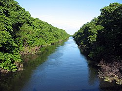
The Rio Cocó is a river in the Brazilian state of Ceará.
Name
The name "Cocó" comes from the plural of the Tupi word kó, , an allusion to the agricultural practices of the indigenous people on the river.
Course
The rivers starts on the eastern slope of Serra da Aratanha, in Pacatuba and passes over the course of 50 kilometers through Maracanaú, Itaitinga and Fortaleza, before discharging into the Atlantic Ocean near Sabiaguaba beach.
Between Pacatuba and Itaitinga, the river includes the Gavião Dam.
Ecosystem
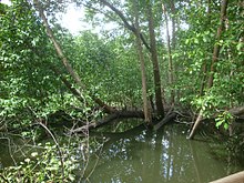
The mouth of the river contains an important Mangrove ecosystem that has been partially restored as part of a mangrove restoration program. A 2021 paper found that even newly restored mangroves in the delta stored a significant amount of organic carbon as a blue carbon.
References
- "Delimitação do Parque do Cocó não incorporou Arie - Metro". Diário do Nordeste (in Brazilian Portuguese). 2019-08-08. Retrieved 2021-10-22.
- Aragão, R. B, Índios do Ceará e Topônimos indígenas, Fortaleza, Barraca do Escritor Cearense. 1994. pag. 125
- Navarro, E. A. Dicionário de tupi antigo. São Paulo. Global. 2013. p. 227.
- "Estudo: Rio Cocó está 100% poluído - Metro". Diário do Nordeste (in Brazilian Portuguese). 2013-09-24. Retrieved 2021-10-22.
- ":: Açudes - Características Técnias". atlas.srh.ce.gov.br. Archived from the original on 2022-06-07. Retrieved 2021-10-22.
- ^ Jimenez, Laís Coutinho Zayas; Queiroz, Hermano Melo; Otero, Xosé Luis; Nóbrega, Gabriel Nuto; Ferreira, Tiago Osório (January 2021). "Soil Organic Matter Responses to Mangrove Restoration: A Replanting Experience in Northeast Brazil". International Journal of Environmental Research and Public Health. 18 (17): 8981. doi:10.3390/ijerph18178981. PMC 8431229. PMID 34501570.
3°46′15″S 38°26′08″W / 3.7709°S 38.4355°W / -3.7709; -38.4355
This article related to a river in Ceará, Brazil is a stub. You can help Misplaced Pages by expanding it. |