| Cockeysville Marble | |
|---|---|
| Stratigraphic range: Precambrian, Cambrian, or Ordovician | |
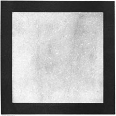
 Polished slab of the marble from Cockeysville. Width of slab inside black border is approximately 10.7 cm. Polished slab of the marble from Cockeysville. Width of slab inside black border is approximately 10.7 cm. | |
| Type | metamorphic |
| Unit of | Glenarm Supergroup |
| Underlies | Wissahickon Formation |
| Overlies | Setters Formation |
| Thickness | about 750 feet |
| Lithology | |
| Primary | marble |
| Location | |
| Region | Piedmont of Maryland |
| Type section | |
| Named for | Cockeysville, Maryland |
| Named by | Williams and Darton, 1892 |
The Cockeysville Marble is a Precambrian, Cambrian, or Ordovician marble formation in Baltimore, Carroll, Harford and Howard Counties, Maryland. It is described as a predominantly metadolomite, calc-schist, and calcite marble, with calc-gneiss and calc-silicate marble being widespread but minor.

The extent of this formation was originally mapped in 1892 within Baltimore County.
Quarrying
The Cockeysville Marble has been quarried in Beaver Dam within Cockeysville and other locations in Maryland. A historical account is given in Maryland Geological Survey Volume Two.
The Cockeysville was also mined for crushed stone at what is now called Quarry Lake. It was known as the McMahon Quarry in the 1940s.
The Cockeysville was mined by Lafarge and by Martin Marietta Inc. at the Marriottsville Quarry, Marrtiottsville, Maryland.
Cockeysville marble was used in the construction of the Washington Monument in Washington D.C. and the Washington Monument in Baltimore.
See also
References
- ^ Geologic Map of Maryland, 1968. Cleaves, E. T., Edwards, J. Jr., and Glaser, J. D. Maryland Geological Survey. Scale 1:250,000.
- ^ Williams, G.H., and Darton, N.H., 1892, Geologic map of Baltimore and vicinity: U.S. Geological Survey, Map to accompany "Guide to Baltimore".
- Maryland Geological Survey Volume Two, by W. B. Clark, 1898. Johns Hopkins University Press. (Google Books)
- McMahon Quarry (Greensberg Quarry), Bare Hills, Baltimore Co., Maryland, USA

