| Col de Soladier | |
|---|---|
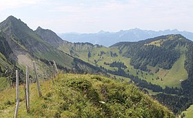
 Col de Soladier between Vanil des Artses and Le Pila on the left and Le Molard on the right Col de Soladier between Vanil des Artses and Le Pila on the left and Le Molard on the right | |
| Elevation | 1,576 m (5,171 ft) |
| Location | Vaud, Switzerland |
| Range | Bernese Alps |
| Coordinates | 46°28′36″N 6°58′02″E / 46.47667°N 6.96722°E / 46.47667; 6.96722 |
 | |
The col de Soladier (1,576 m or 5,171 ft) is a mountain pass in the canton de Vaud, in Switzerland. It is located 1 km west of a ridge linking the Vanil des Artses and the Cape au Moine, and east of Le Molard.

Toponymy
In vaudois dialect, its name is sor la diez, which means : on the spring.
Activities
The col de Soladier is a popular destination for hiking, mountain biking, snowshoeing and ski touring. It is possible to reach the col de Jaman by using a small mountain trail.
See also
References
- "SwissTopo Maps". SwissTopo. Retrieved 12 December 2014.
- "Noms de lieux de Suisse romande, Savoie et environs (in French)". Retrieved 12 December 2014.
This Vaud location article is a stub. You can help Misplaced Pages by expanding it. |