| Corona | |
|---|---|
| Hamlet | |
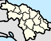
 La Corona (red) in Manajanabo (orange) in Santa Clara La Corona (red) in Manajanabo (orange) in Santa Clara | |
   | |
| Coordinates: 22°22′10″N 79°50′06″W / 22.3695724°N 79.8349816°W / 22.3695724; -79.8349816 | |
| Country | Cuba |
| Province | Villa Clara |
| Municipality | Santa Clara |
| Popular Council | Manajanabo |
| Postal code | 50100 |
Corona or La Corona is a hamlet in Manajanabo, Santa Clara, Villa Clara, Cuba.
References
- "La Corona (Santa Clara) Street Guide and Map". cuba-streets.openalfa.com.
- "La Corona, Villa Clara, Cuba". Cu.geoview.info. Retrieved 2022-09-04.
- "EVALUACIÓN GEOAMBIENTAL DE LA CIUDAD Y EL MUNICIPIO DE SANTA CLARA, CUBA, PARA EL PERFECCIONAMIENTO DEL SISTEMA DE VIGILANCIA EN SALUD" (in Spanish). p. 5.
- "La Corona Villa Clara Postal / ZIP codes and streets list - Getpostalcodes.com". www.getpostalcodes.com.
- "La Corona Postcodes, Postal Codes, ZIP Codes, La Corona PIN Code and Elevation. - AZPostcodes.com". www.azpostcodes.com.
This Cuban location article is a stub. You can help Misplaced Pages by expanding it. |