Misplaced Pages

County of Dawson

Article snapshot taken from Wikipedia with creative commons attribution-sharealike license. Give it a read and then ask your questions in the chat. We can research this topic together.

Cadastral in Queensland, Australia
Dawson
Queensland
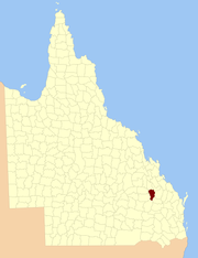
Location within Queensland
Lands administrative divisions around Dawson:
Bauhinia Ferguson Pelham
Labouchere Dawson Rawbelle
Labouchere Fortescue Wicklow
Map all coordinates using OpenStreetMap

Download coordinates as:

The County of Dawson is a county (a cadastral division) in Queensland, Australia, located in the Shire of Banana in Central Queensland. The county is divided into civil parishes. The county was officially named and bounded by the Governor in Council on 7 March 1901 under the Land Act 1897.

Parishes

Dawson is divided into parishes, as listed below:

Parish LGA Coordinates Towns
Belmont Banana 24°47′S 150°21′E / 24.783°S 150.350°E / -24.783; 150.350 (Belmont Parish)
Blackman Banana 25°21′S 150°12′E / 25.350°S 150.200°E / -25.350; 150.200 (Blackman Parish)
Camboon Banana 25°05′S 150°30′E / 25.083°S 150.500°E / -25.083; 150.500 (Camboon Parish) Camboon
Colombo Banana 24°51′S 150°30′E / 24.850°S 150.500°E / -24.850; 150.500 (Colombo Parish)
Coteeda Banana 25°09′S 150°12′E / 25.150°S 150.200°E / -25.150; 150.200 (Coteeda Parish)
Cracow Banana 25°24′S 150°19′E / 25.400°S 150.317°E / -25.400; 150.317 (Cracow Parish) Cracow
Dresden Banana 25°16′S 150°22′E / 25.267°S 150.367°E / -25.267; 150.367 (Dresden Parish)
Kianga Banana 24°43′S 150°07′E / 24.717°S 150.117°E / -24.717; 150.117 (Kianga Parish)
Mungungal Banana 25°08′S 150°21′E / 25.133°S 150.350°E / -25.133; 150.350 (Mungungal Parish)
Okangal Banana 25°01′S 150°19′E / 25.017°S 150.317°E / -25.017; 150.317 (Okangal Parish)
Tarramba Banana 24°39′S 150°14′E / 24.650°S 150.233°E / -24.650; 150.233 (Tarramba Parish)
Walloon Banana 24°57′S 150°08′E / 24.950°S 150.133°E / -24.950; 150.133 (Walloon Parish) Theodore
Woolthorpe Banana 24°51′S 150°05′E / 24.850°S 150.083°E / -24.850; 150.083 (Woolthorpe Parish)
Woolton Banana 24°54′S 150°20′E / 24.900°S 150.333°E / -24.900; 150.333 (Woolton Parish)

References

  1. Queensland showing counties / compiled and published at the Survey Department, Brisbane, Brisbane : Survey Dept., 1900.
  2. "Dawson (entry 9450)". Queensland Place Names. Queensland Government. Retrieved 8 September 2015.
  3. Leichhardt District, County of Dawson Maps - G8 Series at Queensland Archives.

24°56′S 150°16′E / 24.933°S 150.267°E / -24.933; 150.267External links

Category: