Village in England
| Cusworth | |
|---|---|
| Village | |
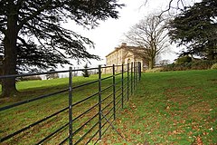
 Cusworth Hall viewed from adjacent parkland Cusworth Hall viewed from adjacent parkland | |
  | |
| Area | 0.93 sq mi (2.4 km) |
| Population | 4,728 (2011 census) |
| • Density | 5,084/sq mi (1,963/km) |
| OS grid reference | SE544050 |
| • London | 145 mi (233 km) SSE |
| Civil parish | |
| Metropolitan borough | |
| Metropolitan county | |
| Region | |
| Country | England |
| Sovereign state | United Kingdom |
| Post town | DONCASTER |
| Postcode district | DN5 |
| Dialling code | 01302 |
| Police | South Yorkshire |
| Fire | South Yorkshire |
| Ambulance | Yorkshire |
| UK Parliament | |
| 53°31′48″N 1°10′30″W / 53.53004°N 1.17505°W / 53.53004; -1.17505 | |
Cusworth is a village and suburb of Doncaster in South Yorkshire, England, located 2 miles (3.2 km) to its north-west within the civil parish of Sprotbrough and Cusworth and the City of Doncaster, with a population of 4,728. It is home to Cusworth Hall, an 18th century country house, and its surrounding parkland. Some buildings in the old village can be dated back to the 16th century.
The village's historic cottages, semi-rural location and situation on the edge of a plateau has led to it sometimes being referred to as ‘a piece of the Cotswolds in Yorkshire’.
History
Cusworth was first recorded as Cuzeuuorde in the Domesday Book of 1086. By 1560, the original manor house and estate belonged to Sir Christopher Wray, who was once Speaker of the House of Commons, and his family. By 1669, it was owned by the Wrightson family. William Wrightson decided in 1740 to build the current Cusworth Hall, which existed as a home for the family until 1961 when the council purchased it and converted it into a museum, which still operates today.
Cusworth has since expanded and is now a relatively affluent commuter village housing professionals working in Doncaster.
Geography
The civil parish of Sprotbrough and Cusworth had a population of 12,134 at the 2011 census.
Cusworth is interwoven with the suburb of Scawsby to the north, and separated from Bentley and Scawthorpe to the east by the A638 dual carriageway. Cusworth Park and agricultural land separate it from Sprotbrough to the south. To the west is rural countryside protected from development by the South and West Yorkshire Green Belt; the A1(M) motorway (Doncaster Bypass) is not far from the village's western edge. Cusworth Lane is the main thoroughfare through Cusworth running from the A638 and eventually connecting with Sprotbrough. It bypasses the ancient village centre, which is accessed via a narrow one-way system.
Amenities
It hosts several local amenities, including a convenience store, public house (The Mallard) and an Italian restaurant. Within the grounds of Cusworth Hall, there is a bistro and a microbrewery. Larger amenities can be found in neighbouring suburbs.
Cusworth is served by the 41 bus service between the Doncaster Frenchgate Interchange and Scawsby, operated by First. The nearest railway stations are in Bentley and Doncaster.
Governance
As part of the Roman Ridge council ward, which also includes Scawsby, it elects two councillors to the City of Doncaster Council. The Cusworth ward of Sprotbrough and Cusworth Parish Council elects four councillors to the parish council and covers the north of Cusworth. The Stadium ward currently has two councillors on the parish council and covers the southern half of Cusworth.
Gallery
-
 Cusworth Hall
-
 Entry to the boathouse on the Upper Fish Pond
-
 Footpath to Sprotbrough with the Upper Fish Pond visible
-
 Stables in Cusworth Park
-
 The Mallard public house
 Panoramic view from Cusworth Hall - from foreground to background: ornamental lake, woodland and agricultural land, Sprotbrough, Doncaster
See also
Notes
References
- "Cusworth Hall & Park". www.heritagedoncaster.org.uk. Retrieved 28 December 2021.
- "Cusworth". www.visitoruk.com. Retrieved 13 February 2022.
- "Cusworth". www.visitoruk.com. Retrieved 13 February 2022.
- UK Census (2011). "Local Area Report – Sprotbrough and Cusworth Parish (E04000091)". Nomis. Office for National Statistics. Retrieved 9 June 2022.
- "Old Brewhouse, Cusworth". www.whatpub.com. Retrieved 28 December 2021.
- "Timetables for Doncaster Service Number 41". www.firstbus.co.uk. Retrieved 20 May 2023.
- "Parish Council Elections". www.sprotbroughandcusworthparishcouncil.gov.uk. Retrieved 31 January 2022.