| Dąbrówka Szlachecka | |
|---|---|
| Neighbourhood and Municipal Information System area | |
 Czeremchowa Street in Dąbrówka Szlachecka, in 2017. Czeremchowa Street in Dąbrówka Szlachecka, in 2017. | |
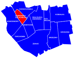
 Location of Dąbrówka Szlachecka within the district of Białołęka, in accordance to the Municipal Information System. Location of Dąbrówka Szlachecka within the district of Białołęka, in accordance to the Municipal Information System. | |
| Coordinates: 52°20′47.11″N 20°57′28.1″E / 52.3464194°N 20.957806°E / 52.3464194; 20.957806 | |
| Country | |
| Voivodeship | Masovian Voivodeship |
| City county | Warsaw |
| District | Białołęka |
| Time zone | UTC+1 (CET) |
| • Summer (DST) | UTC+2 (CEST) |
| Area code | +48 22 |
Dąbrówka Szlachecka is a neighbourhood, and an area of the Municipal Information System, in the city of Warsaw, Poland, located within the district of Białołęka.
History
Dąbrówka Szlachecka was founded in 13th century, as a landed property of the local nobility, and between 16th century, it was a folwark-type settlement belonging to nearby Tarchomin.
In 20th century, Dąbrówka Szlachecka used to be a small village near the city of Warsaw. On 15 May 1951, it had been incorporated into Warsaw.
References
- "Obszary MSI. Dzielnica Białołęka". zdm.waw.pl (in Polish).
- "Osiedla Dąbrówka Szlachecka". bialoleka.um.warszawa.pl (in Polish).
- Andrzej Sołtan (26 November 2014). "Od czasów najdawniejszych po wiek XVIII". bialoleka.um.warszawa.pl (in Polish).
- Rozporządzenie Rady Ministrów z dnia 5 maja 1951 r. w sprawie zmiany granic miasta stołecznego Warszawy. In: 1951 Journal of Laws, no. 27, position 199. Warsaw. 1951.