| Dagu River | |
|---|---|
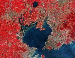
 The Dagu River which flows into the Jiaozhou Bay is clearly visible in this satellite image of Qingdao The Dagu River which flows into the Jiaozhou Bay is clearly visible in this satellite image of Qingdao | |
| Native name | 大沽河 (Chinese) |
| Location | |
| Country | People's Republic of China |
| Province | Shandong Province |
| Physical characteristics | |
| Mouth | |
| • coordinates | 36°10′40″N 120°07′48″E / 36.1779°N 120.1299°E / 36.1779; 120.1299 |
| Length | 180 kilometers |
The Dagu River (Chinese: 大沽河; pinyin: Dàgū Hé) is a 180-km-long river in Shandong province, China, originating from Mount Fu (阜山) in Zhaoyuan, Shandong and emptying into the Jiaozhou Bay in Qingdao. It has a drainage area of 6131.3 km and is responsible for over 85% of the fresh water supply to the Jiaozhou Bay.
References
- Du, Fu-hui; Tao, Li; Chen, Xin-mei; Yao, Huai-xian (2019). "Runoff Simulation Using SWAT Model in the Middle Reaches of the Dagu River Basin". Sustainable Development of Water Resources and Hydraulic Engineering in China. Springer Publishing. pp. 115–126. ISBN 978-3-319-61629-2.
- Chen, Xiao-ying; Liu, Da-hai; Yin, Ping; Liu, Jin-qing; Cao, Ke; Gao, Fei (2019). "Temporal and spatial evolution of surface sediments characteristics in the Dagu River estuary and their dynamic response mechanism". China Geology. 2 (3): 325–332. doi:10.31035/cg2018092.
This article related to a river in China is a stub. You can help Misplaced Pages by expanding it. |