Human settlement in Scotland
Dalnabreck
| |
|---|---|
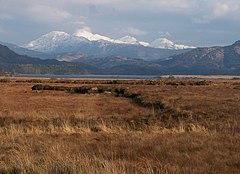
 Peat banks between Mingarry and Dalnabreck, looking west. Peat banks between Mingarry and Dalnabreck, looking west. | |
 | |
| OS grid reference | NM701697 |
| Council area | |
| Country | Scotland |
| Sovereign state | United Kingdom |
| Post town | Acharacle |
| Postcode district | PH36 4 |
| Police | Scotland |
| Fire | Scottish |
| Ambulance | Scottish |
| 56°45′45″N 5°45′42″W / 56.76252°N 5.76167°W / 56.76252; -5.76167 | |
Dalnabreck (Scottish Gaelic: Dail nam Breac) is a small village, lying at the southwest end of Loch Shiel in Sunart, Lochaber, Scottish Highlands and is in the Scottish council area of Highland.
The A861 road runs through Dalnabreck, with Acharacle two miles (three kilometres) east and Ardmolich one mile (1.5 kilometres) northeast, connected by the A861 road.
References
- "Dalnabreck". The Gazetteer for Scotland. School of GeoSciences, University of Edinburgh and The Royal Scottish Geographical Society. Retrieved 17 June 2018.
This Highland location article is a stub. You can help Misplaced Pages by expanding it. |