| Ráth Bhaile an Dainigh | |
 | |
 | |
| Location | Danestown, County Meath, Ireland |
|---|---|
| Coordinates | 53°37′27″N 6°31′24″W / 53.624134°N 6.523275°W / 53.624134; -6.523275 |
| Type | Ringfort |
| Area | 1,661 square metres (0.410 acres) |
| Diameter | 46 metres (151 ft) |
| History | |
| Material | earth |
| Founded | AD 500–1000 |
| Periods | Middle Ages |
| Designation | National Monument |
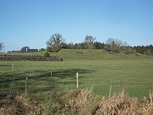
Danestown Fort is a ringfort (rath) and National Monument located in County Meath, Ireland.
Location
Danestown ringfort is located about 700 metres (770 yd) southeast of Kentstown and on the south bank of the Nanny River, a Boyne tributary.
Description
The inner raised circular platform is over 4 metres (13 ft) high with a deep fosse (ditch) and outer bank; the outer bank is over 2 metres (6.6 ft) high in places.
References
- "ME00500 - ROBERTSTOWN - Ringfort - rath". 6 December 2012.
- "Danestown Ringfort". Megalithicireland.com. Retrieved 16 August 2022.