| Dawangguzhuang Town 大王古庄镇 | |
|---|---|
| Town | |
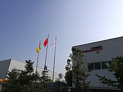
 Orit Cranes Factory within Dawangguzhuang Orit Cranes Factory within Dawangguzhuang | |
  | |
| Coordinates: 39°34′13″N 116°49′13″E / 39.57028°N 116.82028°E / 39.57028; 116.82028 | |
| Country | |
| Municipality | Tianjin |
| District | Wuqing |
| Village-level Divisions | 2 communities 15 villages |
| Area | |
| • Total | 48.75 km (18.82 sq mi) |
| Elevation | 12 m (39 ft) |
| Population | |
| • Total | 25,061 |
| • Density | 510/km (1,300/sq mi) |
| Time zone | UTC+8 (CST) |
| Postal code | 301739 |
| Area code | 022 |
Dawangguzhuang Town (simplified Chinese: 大王古庄镇; traditional Chinese: 大王古莊鎮; pinyin: Dàwánggǔzhuāng Zhèn) is a town located inside of Wuqing District, Tianjin, China. It borders Yongledian and Gaocun Towns in the north, Baigutun Town in the east, Chengguan and Beiwang Towns in the south, and Yaohualu Subdistrict in the west. In 2010, the population of the town was 25,061.
In the early years of the Tang Dynasty, a local rebellion force constructed a fortified village named Wangguzhuang (Chinese: 王固庄; lit. 'Wang's Stronghold Villa') in the area. During the Qing Dynasty, the settlement was split into two village, with the larger settlement becoming Dawangguzhuang.
Geography
Dawangguzhuang Town is situated on the south of Fenghe River, with the Beijing–Shanghai Expressway traversing through it. The average elevation of the town is 12 meters above the sea level.
History
| Year | Status | Within |
|---|---|---|
| 1958 - 1961 | Part of Chengguan Hongqi People's Commune | Wuqing County, Hebei |
| 1961 - 1973 | Dawangguzhuang People's Commune | |
| 1973 - 1983 | Wuqing County, Tianjin | |
| 1983 - 2000 | Dawangguzhuang Township | |
| 2000 - 2001 | Wuqing District, Tianjin | |
| 2001 - present | Dawangguzhuang Town |
Administrative divisions
In 2022, Dawangguzhuang Town was made up of 2 residential communities and 15 villages. They are as follows:
Residential communities
- Taiyuandao (泰元道)
- Taifeng Jiayuan (泰丰家园)
Villages
- Songjiachang (宋家场)
- Zhangjiachang (张家场)
- Dongjiazhuang (董家庄)
- Qianhoushang (前侯尚)
- Lishangtun (利尚屯)
- Shuihuopu (水活铺)
- Niexinzhuang (聂辛庄)
- Daying (大营)
- Chengezhuang (陈各庄)
- Juchengbao (距城堡)
- Dingxinzhuang (丁辛庄)
- Nieying (聂营)
- Hangzhihuiying (韩指挥营)
- Zaolin (枣林)
- Beiliuzhuang (北刘庄)
See also
References
- "China: Tiānjīn Municipal Province (Districts and Townships) - Population Statistics, Charts and Map". www.citypopulation.de. Retrieved 2023-07-16.
- ^ 中华人民共和国政区大典 天津卷 [Collection of Administrative Divisions of the People's Republic of China, Tianjin Volumn] (in Chinese) (Di 1 ban ed.). 2020. ISBN 978-7-5087-6215-9. OCLC 1351675957.
- "Dawangguzhuang topographic map, elevation, terrain". Topographic maps. Retrieved 2023-07-16.
- "2022年统计用区划代码和城乡划分代码" [2022 Statistical Division Codes and Urban-rural Differentiation Codes]. www.stats.gov.cn (in Chinese). Archived from the original on 2023-03-21. Retrieved 2023-07-16.
| Subdivisions of Wuqing District, Tianjin | |
|---|---|
| Subdistricts | |
| Towns | |