| Dent de Corjon | |
|---|---|
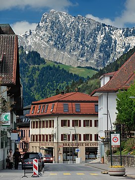
 The east face from Château-d'Oex The east face from Château-d'Oex | |
| Highest point | |
| Elevation | 1,967 m (6,453 ft) |
| Prominence | 579 m (1,900 ft) |
| Coordinates | 46°27′0″N 7°2′9″E / 46.45000°N 7.03583°E / 46.45000; 7.03583 |
| Geography | |
 | |
| Location | Vaud, Switzerland |
| Parent range | Swiss Prealps |
The Dent de Corjon (1,967 m) is a mountain of the Swiss Prealps, located west of Rossinière in the canton of Vaud. It is the culminating point of the small range lying between the valley of L'Hongrin and the Sarine, north of the Lac de l'Hongrin.
References
- Retrieved from the Swisstopo topographic maps. The key col is La Lécherette (1,388 m).
External links
This article about a mountain, mountain range, or peak located in Vaud is a stub. You can help Misplaced Pages by expanding it. |