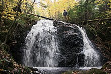
| Devils Hill Falls | |
|---|---|
 Lower Devils Hill Falls, Victoria County, Nova Scotia Lower Devils Hill Falls, Victoria County, Nova Scotia | |
  | |
| Location | Devils Hill, Nova Scotia, Canada |
| Coordinates | 45°58′41.43″N 60°01′44.53″W / 45.9781750°N 60.0290361°W / 45.9781750; -60.0290361 |
| Type | Upper & Lower classical ledge waterfalls connected by a cascade |
| Total height | 12.5 metres (41 ft) |
| Number of drops | 3 |
| Longest drop | 6 metres (20 ft) |
| Watercourse | Devils Hill Brook |
Devils Hill Falls is a waterfall on Devils Hill Brook, flowing off Devils Hill, sited approximately 5.5 kilometres (3.4 mi) south of the Mira River on Cape Breton Island, in the province of Nova Scotia, Canada. The waterfall is in three parts, an upper classical ledge waterfall, about 6 metres (20 ft) of fall, followed by a cascade leading to the lower falls, another classical ledge waterfall, about 4.5 metres (15 ft) in height. The waterfall is a short distance off of New Boston Road, about 3 kilometres (1.9 mi) from the community of Catalone. The falls are located on privately owned property.
The Devils Hill Road Trail
The falls are a short hike, about a 230 metres (750 ft), in from New Boston Road to where the trail crosses the brook on a small bridge. The lower falls are just downstream of the bridge, the upper falls upstream, about 60 metres (200 ft) along a path running along the east side of the brook.
The Devils Hill Road trail is actually the old Devil’s Hill Road to Terra Nova. After visiting the falls it is worth a walk further to where the country opens up as the views are wonderful, especially in the fall. Devils Hill road continues 3.3 kilometres (2.1 mi) to meet the Terra Nova Road, and while the New Boston road end is no longer maintained by the province, it remains a provincially owned road so is open for the public's use. After about 2 kilometres (1.2 mi) the road will improve from a trail to a maintained road with a few scattered homes before meeting the Terra Nova Road.
Local tradition explains the name Devil's Hill, and the Devil's Hill Road that runs along the side of the hill, were named so because a gentleman met the Devil on his way home from Mira Ferry, or possibly New Boston, one night after a dance in the late 19th century.
There were quite a few farms along the road that went to the Mira, a few of them owned by German families and Gael families from Scotland. Many long gone now, returned to forest.
Geocache
There is a small traditional geocache at the falls, located so it is accessible year round, which has been in place since February 2005.
Gallery
-
 The Trail Head of Devils Hill Road, on the New Boston Road.
-
 Upper Falls
-
 The cascade and flume between upper and lower falls.
-
 Lower Falls
-
 Along the Devils Hill Road.
-
 Along the Devils Hill Road.
-
 Along the Devils Hill Road, looking West by Northwest up the road left, MacPhersons Meadows in the distance centre, with Catalone Lake off to East (far right) in the distance.
References
- "Devils Hill". Canadian Geographical Names Data Base (CGNDB). Natural Resources Canada. Retrieved 19 April 2020.
- "Devils Hill". Nova Scotia GeoNAMES Explorer. Province of Nova Scotia. Retrieved 22 April 2020.
Original Decision Date: 20 February 1976
- Ellison, Wally (2013). Waterfalls: Cape Breton's hidden treasures (first ed.). The Author.
- "Devils Hill Falls". Hike Cape Breton. Retrieved 19 April 2020.
- "Devil's Hill Falls". Moosebait.com. Retrieved 19 April 2020.
- Faubert, Victor (17 October 2012). "Views from Devils Hill". Vic’s Web Site. Jackson, New Jersey: Victor Maurice Faubert. Retrieved 25 April 2020.
- Young, Adam. "5 Easy Hikes Near the Fortress of Louisbourg". cbisland.com. Destination Cape Breton Association Inc. Retrieved 22 April 2020.
- Geocaching Home - Cache Details GCMPBP, Groundspeak, retrieved 20 April 2020
External links
- Victor Faubert's Web Site - Devils Hill Falls
- Victor Faubert's Web Site - Views from Devils Hill
- Map of falls, trail, bridge and path to upper falls