| Dewa Mountains | |
|---|---|
| 出羽山地 (Japanese) | |
 Mount Chōkai Mount Chōkai | |
| Highest point | |
| Peak | Mount Chōkai |
| Elevation | 2,236 m (7,336 ft) |
| Coordinates | 39°30′0″N 140°9′36″E / 39.50000°N 140.16000°E / 39.50000; 140.16000 |
| Geography | |
  | |
| Country | Japan |
| Prefectures | Aomori Akita Yamagata |
| Parent range | Japanese Alps |
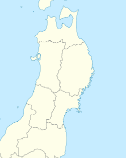
Dewa Mountains (Japanese: 出羽山地) is a mountain range that runs north and south on the west side of the Tohoku region of Japan. The mountain range spans Aomori, Akita, and Yamagata prefectures. The Dewa Mountains are split into several sub-ranges by the Yoneshiro River, the Omono River and the Mogami River. These sub-ranges include the Shirakami Mountains, the Tahei Mountains, The Choki Mountains, and the Chotake Mountains.The highest peak of the mountain range is Mount Chokai (2,236m).
Flora and fauna
The Dewa Mountains are predominately covered with Beech forest. In particular the Shirakawa mountains (Shirakawa-Sanchi) contain the last area of virgin Siebold’s beech forest - the remnants of a forest which once covered most of northern Japan. In 1993 this forest became one of the first areas in Japan listed as a UNESCO World Heritage site.
Dewa mountains in culture
The range is the focal point for the Akinomine (秋の嶺 "peak of autumn") ritual, which is observed by the Mount Haguro lineage of Shugendō.
Individual mountains in the Dewa Mountain range
Mount Haguro
Mount Chokai
See also
References
- "Japan Ultra-Prominences". Peaklist.org. Retrieved 2015-01-01.
- ^ 第2版, ブリタニカ国際大百科事典 小項目事典,デジタル大辞泉,日本大百科全書(ニッポニカ),百科事典マイペディア,精選版 日本国語大辞典,世界大百科事典. "出羽山地とは". コトバンク (in Japanese). Retrieved 2021-05-25.
{{cite web}}: CS1 maint: multiple names: authors list (link) CS1 maint: numeric names: authors list (link) - "でわさんち【出羽山地】 | て | 辞典". 学研キッズネット (in Japanese). Retrieved 2021-05-25.
- "【出羽山地】とは・意味 | エキサイト辞書". エキサイト辞書 (in Japanese). Archived from the original on 2021-05-25. Retrieved 2021-05-25.
- ^ 日本の自然2 東北 (Japanese Nature 2: Tohoku) ISBN 4-00-007932-8
- "秋田県の地形・地盤 : ジオテック株式会社". www.jiban.co.jp. Retrieved 2024-09-14.
- 第2版,世界大百科事典内言及, 日本大百科全書(ニッポニカ),事典・日本の観光資源,国指定史跡ガイド,ブリタニカ国際大百科事典 小項目事典,百科事典マイペディア,デジタル大辞泉,精選版 日本国語大辞典,事典 日本の地域遺産,世界大百科事典. "鳥海山とは". コトバンク (in Japanese). Retrieved 2021-05-25.
{{cite web}}: CS1 maint: multiple names: authors list (link) CS1 maint: numeric names: authors list (link) - "Shirakami Sanchi". www.japan-guide.com. Retrieved 2024-09-14.
- Ōuchi, Fumi; 大内典 (2009). "The Lotus Repentance Liturgy of Shugendō: Identification from Vocal Arts". Cahiers d'Extrême-Asie. 18: 169–193. doi:10.3406/asie.2009.1336. ISSN 0766-1177. JSTOR 44167438.
This Japanese location article is a stub. You can help Misplaced Pages by expanding it. |