| Dingolshausen | |
|---|---|
| Municipality | |
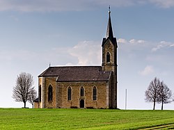
 Pilgrimage Church of Our Lady of Help in Bischwind Pilgrimage Church of Our Lady of Help in Bischwind | |
 Coat of arms Coat of arms | |
Location of Dingolshausen within Schweinfurt district
 | |
  | |
| Coordinates: 49°54′N 10°24′E / 49.900°N 10.400°E / 49.900; 10.400 | |
| Country | Germany |
| State | Bavaria |
| Admin. region | Unterfranken |
| District | Schweinfurt |
| Municipal assoc. | Gerolzhofen |
| Government | |
| • Mayor (2020–26) | Nicole Weissenseel-Brendler |
| Area | |
| • Total | 10.23 km (3.95 sq mi) |
| Elevation | 270 m (890 ft) |
| Population | |
| • Total | 1,419 |
| • Density | 140/km (360/sq mi) |
| Time zone | UTC+01:00 (CET) |
| • Summer (DST) | UTC+02:00 (CEST) |
| Postal codes | 97497 |
| Dialling codes | 09382 |
| Vehicle registration | SW |
| Website | www.dingolshausen.de |
Dingolshausen is a municipality in the district of Schweinfurt in Bavaria, Germany.
Located at the foot of the Steigerwald (forest) and in the valley of a creek named the Volkach. Dingolshausen is known for its wineries.
Coat of arms
The coat of arms was given to Dingolshausen in the year 1561. It shows two grapes as a symbol of the winemakers (Winzwer).
History
The first documented mention of Dingolshausen is in 1165, which was later in the year of 1243 ruled by the Bishopric of Würzburg (Hochstift Wuerzburg).
References
- Liste der ersten Bürgermeister/Oberbürgermeister in kreisangehörigen Gemeinden, Bayerisches Landesamt für Statistik, 15 July 2021.
- Genesis Online-Datenbank des Bayerischen Landesamtes für Statistik Tabelle 12411-003r Fortschreibung des Bevölkerungsstandes: Gemeinden, Stichtag (Einwohnerzahlen auf Grundlage des Zensus 2011).
This Schweinfurt district location article is a stub. You can help Misplaced Pages by expanding it. |