You can help expand this article with text translated from the corresponding article in Slovak. (April 2009) Click for important translation instructions.
|
| Spišský Štvrtok | |
|---|---|
| Village | |
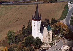
 Church of St. Ladislaus in the village Church of St. Ladislaus in the village | |
 Coat of arms Coat of arms | |
  | |
| Coordinates: 49°00′N 20°28′E / 49.000°N 20.467°E / 49.000; 20.467 | |
| Country | |
| Region | Prešov |
| District | Levoča |
| First mentioned | 1263 |
| Area | |
| • Total | 14.23 km (5.49 sq mi) |
| Elevation | 546 m (1,791 ft) |
| Population | |
| • Total | 2,580 |
| Postal code | 053 14 |
| Area code | +421 53 |
| Car plate | LE |
| Website | www.spisskystvrtok.sk |
Spišský Štvrtok (before 1927 "Štvrtok"; German: Donnersmark, Hungarian: Csütörtökhely, Polish: Spiski Czwartek) is a village and municipality in Levoča District in the Prešov Region of central-eastern Slovakia. In historical records the village was first mentioned in 1263. The municipality lies at an elevation of 560 metres and covers an area of 14.237 km. It has a population of about 2,334 people.
The name of the village means "Thursday", referring to its historical market-day. Name before 1242 was Szentlászló after Ladislaus I of Hungary
People
- Henckel von Donnersmarck
- Szapolya family
- Mikuláš Dzurinda, former prime minister of Slovakia.
- Štefan Sečka, a former Roman Catholic auxiliary bishop of the Roman Catholic Diocese of Spiš
References
- "Počet obyvateľov podľa pohlavia - obce (ročne)". www.statistics.sk (in Slovak). Statistical Office of the Slovak Republic. 2022-03-31. Retrieved 2022-03-31.
- ^ "Hustota obyvateľstva - obce [om7014rr_ukaz: Rozloha (Štvorcový meter)]". www.statistics.sk (in Slovak). Statistical Office of the Slovak Republic. 2022-03-31. Retrieved 2022-03-31.
- ^ "Základná charakteristika". www.statistics.sk (in Slovak). Statistical Office of the Slovak Republic. 2015-04-17. Retrieved 2022-03-31.
- ^ "Hustota obyvateľstva - obce". www.statistics.sk (in Slovak). Statistical Office of the Slovak Republic. 2022-03-31. Retrieved 2022-03-31.
External links
This Prešov Region geography article is a stub. You can help Misplaced Pages by expanding it. |