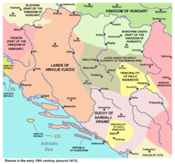
Drina (Serbian Cyrillic: Дрина, pronounced [drǐːna]) was a medieval župa (parish), and later zemlja, located in what is now Podrinje, the region in the Drina river valley, shared by (eastern) Bosnia and Herzegovina and (western) Serbia. Its location and spreading is unclear, although assumed to be located in middle and upper course of the river Drina, on its left bank in Bosnia and Herzegovina. Podrinje was part of the first Serbian principality, in the Early Middle Ages. John Kinnamos (1143–1185) noted that the river Drina separated Bosnia from Serbia, while one Papal document from 1187 erroneously identified Bosnia as part of Serbia. Early medieval Bosnian state included regions on the left bank of the Drina, where the župa was located. Bosnian noble family of Pavlović ruled the region, along with other feudal possessions that extended from the middle and Upper Drina river to the south-southeastern regions of the Bosnian realm in Hum and Konavle at the Adriatic coast. The family official residence and seat was at Borač and later Pavlovac, above the Prača river canyon, between present-day Prača, Rogatica and Goražde (all in Bosnia and Herzegovina). Also, it was part of the dominion of the Kosača noble family, while another lesser Bosnian noble family had their possessions in the region, namely Dinjčić noble family's.
The Drina župa was mentioned in the Chronicle of the Priest of Duklja (CPD, ca. 1300), as the site of a battle and the fief of Serbian nobleman Tihomir during Prince Časlav's reign (927–960). In 1359, veliki čelnik Dimitrije (fl. 1349–59) is mentioned as holding Gacko, Drina, Dabar, and Rudine.
Drina is further mentioned as an area with Soko (transl. Falcone) fortress in 1444, as a dominium (lordship, knežina) in 1448, as a lordship with Soko fortress in 1454.
References
- Novaković 2010.
- SKA 1935, p. 10.
- Vego 1982, pp. 18, 25 "Knez Ratimir bi bio prvi poznati knez na području Bosne kao samostalne oblasti."
- Hadžijahić, Muhamed (2004). Povijest Bosne u IX i X stoljeću (in Serbo-Croatian) (from the original University of Michigan ed.). Sarajevo: Preporod. pp. 14, 15, 32, 33. ISBN 9789958820274. Retrieved 28 December 2019.
Vladavina Bladinova nasljednika Ratimira može se datirati u 838. godinu.
- Mrgić-Radojčić, Jelena (2002). Donji Kraji: Krajina srednjovekovne Bosne (in Serbo-Croatian). Filozofski fakultet. p. 32. ISBN 978-86-80269-59-7. Retrieved 26 November 2019.
- "Borak (Han-stjenički plateau) necropolis with stećak tombstones in the village of Burati, the historic site". Commission to preserve national monuments (in Bosnian). Retrieved 2 February 2019.
- Živković 2006, p. 53.
- SKA 1908, p. 196.
- Vego 1980, p. 455.
Sources
- Novaković, Relja (2010) . "Gde se nalazila Srbija od VII do XII veka: Zaključak i rezime monografije" (Internet ed.).
- Živković, Tibor (2006). Portreti srpskih vladara (IX—XII vek). Belgrade. pp. 11–20. ISBN 86-17-13754-1.
{{cite book}}: CS1 maint: location missing publisher (link) - Blagojević, Miloš (2001). Državna uprava u srpskim srednjovekovnim zemljama. Službeni list SRJ. pp. 212, 294, 301. ISBN 9788635504971.
- Vego, Marko (1980). Iz istorije srednjovjekovne Bosne i Hercegovine. "Svjetlost," OOUR Izdavačka djelatnost.
- Vego, Marko (1982). Postanak srednjovjekovne bosanske države (in Croatian). Svjetlost.
- SKA (1908). Glas. Vol. 78–80. SKA. p. 196.
- SKA (1935). Glas. Vol. 167. SKA. p. 10.
44°11′31″N 19°23′07″E / 44.1920514°N 19.385376°E / 44.1920514; 19.385376
Category: