| Dunkeld Bridge | |
|---|---|
 The River Tay flowing beneath the bridge, looking south The River Tay flowing beneath the bridge, looking south | |
| Coordinates | 56°33′50″N 3°35′07″W / 56.5639°N 3.5853°W / 56.5639; -3.5853 |
| Crosses | River Tay |
| Locale | Dunkeld, Perth and Kinross, Scotland |
| Characteristics | |
| Total length | 685 feet (209 m) |
| Width | 26.5 feet (8 m) |
| Height | 54 feet (16 m) |
| History | |
| Opened | 1809; 216 years ago (1809) |
| Location | |
Dunkeld Bridge is a seven-arch bridge crossing the River Tay at Dunkeld, Perth and Kinross, Scotland. It carries the pedestrian and vehicle traffic of Bridge Street (the A923) and connects the parishes of Dunkeld and Dowally to the north and Little Dunkeld to the south. A Category A listed structure, it is 685 feet (209 m) long, 26.5 feet (8 m) wide and 54 feet (16 m) high. Its middle arch is 90 feet (27 m) wide, two others are 84 feet (26 m), two more are 74 feet (23 m) and the land-arches are 20 feet (6 m). The pontage was abolished in 1879.
The bridge was built between 1805 and 1809 by Thomas Telford. It cost £33,978.
 Aerial view of Dunkeld (left), the bridge and Little Dunkeld, looking east towards Meikleour
Gallery
-
 A commemorative plaque on the bridge marking the structure's bicentenary in 2009
-
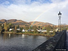
 Dunkeld, and a lantern on the bridge
-
 Western view
-
 Eastern view
See also
References
- Dunkeld, Bridge Street, Dunkeld Bridge – Canmore
- ^ Dunkeld Bridge Over River Tay – Historic Environment Scotland
- ^ Ordnance Gazetteer of Scotland: A Graphic and Accurate Description of Every Place in Scotland, Frances Hindes Groome (1901), p. 436
This article about a bridge in the United Kingdom is a stub. You can help Misplaced Pages by expanding it. |