| East Street Western Australia | |
|---|---|
 | |
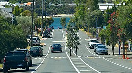
| From top of street looking toward Swan River | |
| General information | |
| Type | Street |
| Length | 1.1 km (0.7 mi) |
| Major junctions | |
| South end |
|
| |
| North end |
|
| Location(s) | |
| Suburb(s) | Fremantle, East Fremantle |

East Street in a street located in Fremantle, Western Australia. It runs between High Street and Beach Street on the southern shore of the Swan River. The intersection with High Street is at the north east corner of the Monument Hill reserve. It also intersects with Ellen Street and Burt Street on its western side.
It crosses Canning Highway before a steep drop to the level of Beach Street.
Located on the western side of the street is the John Curtin College of the Arts The cutting and its edges at the southern end of the street has required maintenance over time. The Swan River end of the street, a jetty known locally as the East Street Jetty, has been the location for a number of events.
Intersections
| LGA | Location | km | mi | Destinations | Notes |
|---|---|---|---|---|---|
| Fremantle | Fremantle | 0 | 0.0 | Traffic light controlled; East Street continues south as Swanbourne Street | |
| 0.13 | 0.081 | Ellen Street / Holland Street | Stop sign controlled, giving East Street priority | ||
| Fremantle-East Fremantle boundary | Fremantle-East Fremantle boundary | 0.4 | 0.25 | Marmion Street | Stop sign controlled, giving East Street priority |
| 0.45 | 0.28 | Vale Street | Stop sign controlled, giving East Street priority | ||
| 0.55 | 0.34 | Burt Street | Stop sign controlled, giving East Street priority | ||
| 0.6 | 0.37 | Malcolm Street | Stop sign controlled, giving East Street priority | ||
| 0.75 | 0.47 | Dorothy Street / George Street | Roundabout | ||
| 0.95 | 0.59 | Stop sign controlled, giving Canning Highway priority | |||
| 1.1 | 0.68 | Beach Street / Riverside Road | Stop sign controlled, giving Beach Street and Riverside Road priority | ||
| 1.000 mi = 1.609 km; 1.000 km = 0.621 mi | |||||
Notes
- ^ "East Street". Google Maps. Retrieved 24 November 2022.
- "A FREMANTLE STREET". The West Australian. Vol. 15, no. 4, 304. Western Australia. 18 December 1899. p. 6. Retrieved 18 June 2022 – via National Library of Australia.
- "Dangerous Fencing". The Advertiser. Vol. I, no. 32. Western Australia. 5 August 1921. p. 6. Retrieved 18 June 2022 – via National Library of Australia.
- "Perth Will Have Full Milk Supply". The Daily News. Vol. LXIV, no. 22, 334 (HOME ed.). Western Australia. 7 November 1946. p. 28. Retrieved 15 January 2017 – via National Library of Australia.
- "Boys Swim Close To Zephyr". The Daily News. Vol. LVIII, no. 20, 268 (CITY FINAL ed.). Western Australia. 14 March 1940. p. 6. Retrieved 15 January 2017 – via National Library of Australia.
- "MUNICIPAL". The Inquirer and Commercial News. Vol. LVVI, no. 3348. Western Australia. 21 June 1901. p. 14. Retrieved 18 June 2022 – via National Library of Australia.
| Streets of Fremantle, Western Australia, Australia | ||||||
|---|---|---|---|---|---|---|
| Fremantle city centre |
| |||||
| Greater Fremantle | ||||||