Misplaced Pages

Eastern Land Division

Article snapshot taken from Wikipedia with creative commons attribution-sharealike license. Give it a read and then ask your questions in the chat. We can research this topic together.

Land division in Western Australia, Australia
Eastern Land Division
Land division
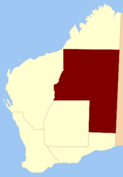
Location within Western Australia prior to 1917Location within Western Australia prior to 1917
Coordinates: 24°45′S 125°00′E / 24.750°S 125.000°E / -24.750; 125.000
Country Australia
StateWestern Australia
RegionsGoldfields–Esperance
Pilbara
Land districts40 land districts

The Eastern Land Division is one of five cadastral divisions of Western Australia, within the eastern parts of the Goldfields-Esperance region and the Pilbara region. Most of its territory is covered by deserts, including the part of the Great Sandy Desert, Gibson Desert and Great Victoria Desert.

History

The Eastern Land Division was created on 2 March 1887, in a reform to the land divisions. On 28 March 1917, the Central Land Division had been incorporated into the Eastern Land Division. The current boundaries of the land enacted on 30 March 1998.

Prior to the construction of the Trans-Australian Railway in 1917, the Eastern Land Division, which consists almost entirely of the Great Victoria and Great Sandy Deserts, did not contain any districts.

Subdivisions

The Eastern Land Division is subdivided into 40 land districts.

District Location Created Notes
Balladonia 32°15′S 123°35′E / 32.250°S 123.583°E / -32.250; 123.583 (Balladonia Land District) 1897 Partially located within Eucla Land Division
Balwina 20°15′S 127°40′E / 20.250°S 127.667°E / -20.250; 127.667 (Balwina Land District) 1928
Bulga 28°25′S 119°40′E / 28.417°S 119.667°E / -28.417; 119.667 (Bulga Land District) 1903
Buningonia 31°05′S 123°05′E / 31.083°S 123.083°E / -31.083; 123.083 (Buningonia Land District) 1903
Delisser 30°00′S 127°45′E / 30.000°S 127.750°E / -30.000; 127.750 (Delisser Land District) 1916
Dempster 32°40′S 122°55′E / 32.667°S 122.917°E / -32.667; 122.917 (Dempster Land District) 1897 Partially located within Eucla Land Division
Edjudina 29°25′S 122°35′E / 29.417°S 122.583°E / -29.417; 122.583 (Edjudina Land District) 1903
Fraser 32°00′S 122°45′E / 32.000°S 122.750°E / -32.000; 122.750 (Fraser Land District) 1897 Partially located within Eucla Land Division
Giles 30°00′S 125°20′E / 30.000°S 125.333°E / -30.000; 125.333 (Giles Land District) 1916 Partially located within Eucla Land Division
Hampton 30°50′S 121°40′E / 30.833°S 121.667°E / -30.833; 121.667 (Hampton Land District) 1899
Hann 24°50′S 120°50′E / 24.833°S 120.833°E / -24.833; 120.833 (Hann Land District) 1925
Jaurdi 30°25′S 120°50′E / 30.417°S 120.833°E / -30.417; 120.833 (Jaurdi Land District) 1903
Jilbadji 31°25′S 119°25′E / 31.417°S 119.417°E / -31.417; 119.417 (Jilbadji Land District) 1903
Kaluwiri 27°50′S 120°40′E / 27.833°S 120.667°E / -27.833; 120.667 (Kaluwiri Land District) 1903
Malcolm 28°50′S 121°20′E / 28.833°S 121.333°E / -28.833; 121.333 (Malcolm Land District) 1900
Marmion 29°40′S 121°10′E / 29.667°S 121.167°E / -29.667; 121.167 (Marmion Land District) 1899
Milyuga 25°25′S 127°25′E / 25.417°S 127.417°E / -25.417; 127.417 (Milyuga Land District) 1932
Nabberu 26°35′S 120°10′E / 26.583°S 120.167°E / -26.583; 120.167 (Nabberu Land District) 1903
Ngalbain 31°20′S 121°10′E / 31.333°S 121.167°E / -31.333; 121.167 (Ngalbain Land District) 1903
Nuleri 27°40′S 122°10′E / 27.667°S 122.167°E / -27.667; 122.167 (Nuleri Land District) 1903
Pardu 19°50′S 120°40′E / 19.833°S 120.667°E / -19.833; 120.667 (Pardu Land District) 1906 Partially located within Kimberley and North-West Land Divisions
Tugaila 25°25′S 124°25′E / 25.417°S 124.417°E / -25.417; 124.417 (Tugaila Land District) 1932
Ularring 29°25′S 120°05′E / 29.417°S 120.083°E / -29.417; 120.083 (Ularring Land District) 1903
Wanman 22°10′S 123°50′E / 22.167°S 123.833°E / -22.167; 123.833 (Wanman Land District) 1950s
Weld 28°40′S 122°25′E / 28.667°S 122.417°E / -28.667; 122.417 (Weld Land District) 1901
Wells 25°15′S 122°30′E / 25.250°S 122.500°E / -25.250; 122.500 (Wells Land District) 1925
Yamarna 28°10′S 123°40′E / 28.167°S 123.667°E / -28.167; 123.667 (Yamarna Land District) 1930
Yelina 26°20′S 122°10′E / 26.333°S 122.167°E / -26.333; 122.167 (Yelina Land District) 1903
Yilgarn 30°50′S 119°05′E / 30.833°S 119.083°E / -30.833; 119.083 (Yilgarn Land District) 1900
Yowalga 27°55′S 127°00′E / 27.917°S 127.000°E / -27.917; 127.000 (Yowalga Land District) 1932

References

  1. ^ "LAND ADMINISTRATION ACT 1997 - SCHEDULE 1". Retrieved 1 December 2010.
  2. "Land Regulations. Part III — Division of the Colony". Western Australia Government Gazette. 2 March 1887. p. 1887:133.
  3. Land Act Amendment Act 1917 (No. 19), s. 4.
  4. Land Administration Act 1997. Proclamation. In: Western Australia Government Gazette. 27 March 1998. p. 1998:1765.
  5. Western Australia. Dept. of Lands and Surveys (1913). South western portion of Western Australia shewing land districts (map), Government Lithographer, Perth.
Categories: