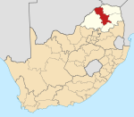
Place in Limpopo, South Africa
| Eerstegoud | |
|---|---|
  | |
| Coordinates: 23°59′06″S 29°21′04″E / 23.985°S 29.351°E / -23.985; 29.351 | |
| Country | South Africa |
| Province | Limpopo |
| District | Capricorn |
| Municipality | Polokwane |
| Time zone | UTC+2 (SAST) |
| PO box | 0701 |
Eerstegoud is a village 14 km south-west of Polokwane. Laid out in 1868, it was first called Marabastad. At the request of the inhabitants the name was changed about 1954 to Eerstegoud, Afrikaans for 'first gold', in memory of the discovery in 1871 of the first gold in the Transvaal at Eersteling by Edward Button.
References
- Raper, Peter E. (1987). Dictionary of Southern African Place Names. Internet Archive. p. 151. Retrieved 11 June 2017.
- "Polokwane the Segregated city | South African History Online".
| Municipalities and communities of Capricorn District Municipality, Limpopo | ||
|---|---|---|
| District seat: Pietersburg (Polokwane) | ||
| Blouberg |
|  |
| Molemole |
| |
| Polokwane |
| |
| Lepelle-Nkumpi | ||
This Limpopo location article is a stub. You can help Misplaced Pages by expanding it. |