| Ejin Horo Banner 伊金霍洛旗 • ᠡᠵᠢᠨ ᠬᠣᠷᠣᠭᠠ ᠬᠣᠰᠢᠭᠤ | |
|---|---|
| Banner | |
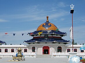
 Mausoleum of Genghis Khan Mausoleum of Genghis Khan | |
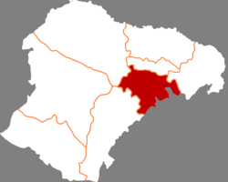
 Ejin Horo in Ordos City Ejin Horo in Ordos City | |
  | |
| Coordinates: 39°33′53″N 109°44′52″E / 39.5647°N 109.7477°E / 39.5647; 109.7477 | |
| Country | China |
| Region | Inner Mongolia |
| Prefecture-level city | Ordos City |
| Banner seat | Altan Xire |
| Area | |
| • Total | 5,958 km (2,300 sq mi) |
| Population | |
| • Total | 247,983 |
| • Density | 42/km (110/sq mi) |
| Time zone | UTC+8 (China Standard) |
| Postal code | 017200 |
| Area code | 0477 |
| Tourism | Mausoleum of Genghis Khan Tourist ger camps |
| Website | www |
| Ejin Horo Banner | |||||||||
|---|---|---|---|---|---|---|---|---|---|
| Chinese name | |||||||||
| Chinese | 伊金霍洛旗 | ||||||||
| Literal meaning | Ejin Horo Banner | ||||||||
| |||||||||
| Mongolian name | |||||||||
| Mongolian Cyrillic | Эзэн Хороо хошуу | ||||||||
| Mongolian script | ᠡᠵᠢᠨ ᠬᠣᠷᠣᠭᠠ ᠬᠣᠰᠢᠭᠤ | ||||||||
| |||||||||
The Ejin Horo Banner, also known as Ejin Horo Qi or Yijinhuoluo County, is a banner in Ordos City in southwestern Inner Mongolia, China. It borders Shaanxi Province to the southeast. As of 2009, the Ejin Horo Banner covers an area of almost 5,600 square kilometres (2,200 sq mi), with a population of nearly 160,000, the majority of whom are ethnically Han Chinese.
China's growing economy has led, in recent years, to increased development in the area of the Ejin Horo Banner, with the construction or improvement of roads, transportation centers, and accommodation for travelers and tourists. It is the site of the Mausoleum of Genghis Khan, a AAAAA-rated tourist attraction that does not contain the body of Genghis Khan or, since the Cultural Revolution, any authentic artifacts from his life but which remains important as a cult site in Mongolian religion.
Name
The banner is named for the Mausoleum of Genghis Khan, whose Mongolian name Ejin Horo translates as "the Lord's Enclosure".
Geography
The Ejin Horo Banner, as part of Ordos City, lies on a plateau in the southern portion of the Ordos Desert. The land surface consists primarily of arid grassland or sandy dunes. A tributary of the Yellow River flows through the banner.
Administrative divisions
Ejin Horo Banner is made up of 7 towns.
| Name | Simplified Chinese | Hanyu Pinyin | Mongolian (Hudum Script) | Mongolian (Cyrillic) | Administrative division code |
|---|---|---|---|---|---|
| Towns | |||||
| Altan Xire Town | 阿勒腾席热镇 | Ālèténgxírè Zhèn | ᠠᠯᠲᠠᠨᠰᠢᠷᠡᠭᠡ ᠪᠠᠯᠭᠠᠰᠤ | Алтанширээ балгас | 150627100 |
| Jasag Town | 札萨克镇 | Zhásàkè Zhèn | ᠵᠠᠰᠠᠭ ᠪᠠᠯᠭᠠᠰᠤ | Засаг балгас | 150627101 |
| Ulan Moron Town | 乌兰木伦镇 | Wūlánmùlún Zhèn | ᠤᠯᠠᠭᠠᠨᠮᠥ᠋ᠷᠡᠨ ᠪᠠᠯᠭᠠᠰᠤ | Улаанумран балгас | 150627102 |
| Narin Tohoi Town | 纳林陶亥镇 | Nàlíntáohài Zhèn | ᠨᠠᠷᠢᠨ ᠲᠣᠬᠣᠢ ᠪᠠᠯᠭᠠᠰᠤ | Нарийн духай балгас | 150627103 |
| Subrag Town | 苏布尔嘎镇 | Sūbù'ěrgā Zhèn | ᠰᠤᠪᠤᠷᠭᠠ ᠪᠠᠯᠭᠠᠰᠤ | Суварга балгас | 150627104 |
| Honqinghe Town | 红庆河镇 | Hóngqìnghé Zhèn | ᠬᠣᠨᠢᠴᠢᠨ ᠭᠣᠣᠯ ᠪᠠᠯᠭᠠᠰᠤ | Хоньчин гол балгас | 150627105 |
| Ejin Horo Town | 伊金霍洛镇 | Yījīnhuòluò Zhèn | ᠡᠵᠡᠨ ᠬᠣᠷᠣᠭᠠ ᠪᠠᠯᠭᠠᠰᠤ | Эзэн хороо балгас | 150627106 |
Others:
- Mengsu Economic Development Zone, Ordos (鄂尔多斯蒙苏经济开发区)
- Ordos Airport Logistics Park (鄂尔多斯空港物流园区)
Environmental issues
Pasture degradation, soil erosion, and desertification were ongoing problems during the late 20th century. From the 1950s through the 1970s, the use of fuel wood and overgrazing from sheep and goats caused up to an estimated annual loss of 1,000 km (390 sq mi) of arable land. During the 1980s, the rate decreased substantially due to government programs and the availability of coal as a household fuel.
Climate
| Climate data for Ejin Horo Banner, elevation 1,367 m (4,485 ft), (1991–2020 normals, extremes 1981–2010) | |||||||||||||
|---|---|---|---|---|---|---|---|---|---|---|---|---|---|
| Month | Jan | Feb | Mar | Apr | May | Jun | Jul | Aug | Sep | Oct | Nov | Dec | Year |
| Record high °C (°F) | 12.7 (54.9) |
16.9 (62.4) |
25.6 (78.1) |
33.2 (91.8) |
34.0 (93.2) |
37.3 (99.1) |
37.4 (99.3) |
34.3 (93.7) |
34.6 (94.3) |
25.9 (78.6) |
20.0 (68.0) |
13.8 (56.8) |
37.4 (99.3) |
| Mean daily maximum °C (°F) | −2.6 (27.3) |
2.0 (35.6) |
8.7 (47.7) |
16.7 (62.1) |
22.6 (72.7) |
27.0 (80.6) |
28.6 (83.5) |
26.4 (79.5) |
21.4 (70.5) |
14.5 (58.1) |
6.2 (43.2) |
−1.1 (30.0) |
14.2 (57.6) |
| Daily mean °C (°F) | −10.2 (13.6) |
−5.6 (21.9) |
1.6 (34.9) |
9.7 (49.5) |
16.0 (60.8) |
20.7 (69.3) |
22.5 (72.5) |
20.4 (68.7) |
14.9 (58.8) |
7.6 (45.7) |
−0.8 (30.6) |
−8.1 (17.4) |
7.4 (45.3) |
| Mean daily minimum °C (°F) | −15.9 (3.4) |
−11.5 (11.3) |
−4.4 (24.1) |
2.9 (37.2) |
9.0 (48.2) |
14.1 (57.4) |
16.7 (62.1) |
15.0 (59.0) |
9.3 (48.7) |
2.0 (35.6) |
−5.9 (21.4) |
−13.3 (8.1) |
1.5 (34.7) |
| Record low °C (°F) | −29.4 (−20.9) |
−28.1 (−18.6) |
−23.3 (−9.9) |
−10.9 (12.4) |
−3.3 (26.1) |
2.1 (35.8) |
8.9 (48.0) |
5.4 (41.7) |
−1.9 (28.6) |
−10.5 (13.1) |
−20.6 (−5.1) |
−29.7 (−21.5) |
−29.7 (−21.5) |
| Average precipitation mm (inches) | 2.0 (0.08) |
2.9 (0.11) |
7.8 (0.31) |
15.3 (0.60) |
27.0 (1.06) |
44.7 (1.76) |
99.5 (3.92) |
86.5 (3.41) |
48.5 (1.91) |
18.2 (0.72) |
7.5 (0.30) |
1.8 (0.07) |
361.7 (14.25) |
| Average precipitation days (≥ 0.1 mm) | 1.6 | 2.1 | 3.3 | 3.5 | 5.9 | 8.8 | 11.4 | 11.3 | 9.0 | 5.1 | 2.6 | 1.5 | 66.1 |
| Average snowy days | 3.3 | 3.7 | 3.4 | 1.2 | 0 | 0 | 0 | 0 | 0 | 1.0 | 2.7 | 3.3 | 18.6 |
| Average relative humidity (%) | 53 | 46 | 39 | 34 | 36 | 45 | 57 | 63 | 60 | 54 | 53 | 52 | 49 |
| Mean monthly sunshine hours | 221.2 | 217.1 | 253.7 | 277.2 | 302.3 | 286.3 | 279.8 | 259.8 | 237.0 | 241.6 | 218.5 | 213.9 | 3,008.4 |
| Percent possible sunshine | 73 | 71 | 68 | 69 | 68 | 64 | 62 | 62 | 64 | 71 | 74 | 74 | 68 |
| Source: China Meteorological Administration | |||||||||||||
Economy
The top industries are coal mining and extraction, mineral extraction, chemical engineering, sheep and goat herding, and cashmere production. Total fossil fuel reserves beneath the Ejin Horo Banner are estimated to be about 27.8 billion tons, which includes coal and natural gas. Although coal mining is of paramount importance to the regional economy, the poorly regulated industry has undermined parts of the area so badly that the ground surface has become unstable in places. Because of the relentless coal extraction, parts of one village began caving in; the residents were re-located starting in 2008 to a planned community called Ulanmulun New Village, and has a capacity of 936 families. Because of ground instability, coal mines producing less than 300,000 were shut down in 2000; those producing less than 600,000 tons annually were closed in 2007, drastically reducing the total number of mines in the area.
An industrial park that will focus on the manufacture of equipment for coal mining and fossil fuel extraction is under construction in the banner. The total cost is expected to be around 10 billion yuan (US$1.46 billion), but is expected to produce 8,000 new jobs, and a potential 40,000 secondary jobs.
Mausoleum of Genghis Khan

The Ejin Horo Banner is also known as the location of the Mausoleum of Genghis Khan. Ethnic Mongolians in China have made pilgrimages to the mausoleum for decades, especially during the annual Naadam Festival every summer. In recent years, there has been an increase in the number of tourists visiting the site, often wealthy urban Chinese on domestic excursions. Local entrepreneurs are attempting to accommodate these visitors, and capitalize on the new situation; government subsidies reflect an attempt to stimulate the improvement of tourist facilities, which have held a AAAAA rating from China's National Tourism Administration since 2011. The mausoleum does not claim to contain the remains of Genghis Khan. A 17th-century source asserts that only the shirt, shoes, and tent of the great khan were buried at the Ejin Horo Banner, and even the few artifacts at the site were destroyed by Red Guards during the Cultural Revolution. There are other locations in Outer Mongolia that lay claim to the final resting place of Genghis Khan.
Near the official Mausoleum, there is a large, privately owned museum and park dedicated to Genghis Khan. There is also a hotel and there are many tourist ger camps in the area, some of which have horses and offer short trail rides.
Transportation
Buses make regular stops in the Ejin Horo Banner when traveling along China National Highway 210.
The nearest train station is about 33 km (21 mi) away in Dongsheng.
Ordos Airport is in the area.
See also
Notes
- For various reasons, the actual tomb of Genghis Khan remains undiscovered.
References
- Inner Mongolia: Prefectures, Cities, Districts and Counties
- 中国民政部-行政区划网 [Ministry of Civil Affairs - Administrative Division Network] (in Chinese). Archived from the original on 2 December 2010. Retrieved 19 January 2011.
- ^ Jianhua, Feng (28 May 2009), "A New Life Near Coalmine: New industries and an infusion of cultural heritage combine to offer opportunity for residents in Ordos", The Beijing Review, retrieved 19 January 2011
- Man, John (2004), Genghis Khan: Life, Death and Resurrection, London: Bantham, p. 286, ISBN 978-0-553-81498-9.
- Kasperson, Jeanne X.; Kasperson, Roger E.; Turner II, B. L., eds. (1995). "The Ordos Plateau of China". Regions at risk: comparisons of threatened environments. New York: United Nations University Press. Retrieved 19 January 2011.
- Zhao, Yongfu (1981). "Change in the Mu Us sandy land in historical time". Historical Geography. 1 (1): 34–47.
- 中国气象数据网 – WeatherBk Data (in Simplified Chinese). China Meteorological Administration. Retrieved 10 October 2023.
- 中国气象数据网 (in Simplified Chinese). China Meteorological Administration. Retrieved 10 October 2023.
- Ratchnevsky (1993). Genghis Khan. Blackwell Publishing. pp. 142–143. ISBN 0-631-18949-1.
- Levy, Joel (2006). Lost Histories. London: Vision Paperbacks. pp. 172–179. ISBN 978-0-7394-8013-7.
- Official website of Ministry of Transport of PRC
External links
- Official website (in Chinese)
| County-level divisions of Inner Mongolia Autonomous Region | |||||||||||||||||||
|---|---|---|---|---|---|---|---|---|---|---|---|---|---|---|---|---|---|---|---|
| Hohhot (capital) | |||||||||||||||||||
| Prefecture-level cities |
| ||||||||||||||||||
| Leagues |
| ||||||||||||||||||